Need accurate linear infrastructure data? Save time, cut costs, and get crystal-clear insights with our advanced drone corridor mapping services.
Don’t settle for risky, time-consuming traditional surveys when our enterprise-grade drone technology delivers faster, safer corridor analysis results.
As specialists in industrial-grade linear asset assessment and right-of-way mapping since 2016, we provide the actionable corridor data you need for critical infrastructure decision-making.
Used By Top UK Businesses

👇Fill Out The Form For Same-Day Drone Survey Quote 👇
Why Leading UK Businesses Choose Our Drone Survey Services:
✅ We’re Fully Licensed, Insured Drone Pilots
✅ We Cover the UK with Fast Response Times
✅ We Only Use Top-Quality Drone Equipment
✅ We Customize Solutions for Your Industry
✅ We Handle All the Paperwork and Permissions
✅ We Have Worked with Hundreds of Happy Customers


What Is Drone Corridor Mapping?
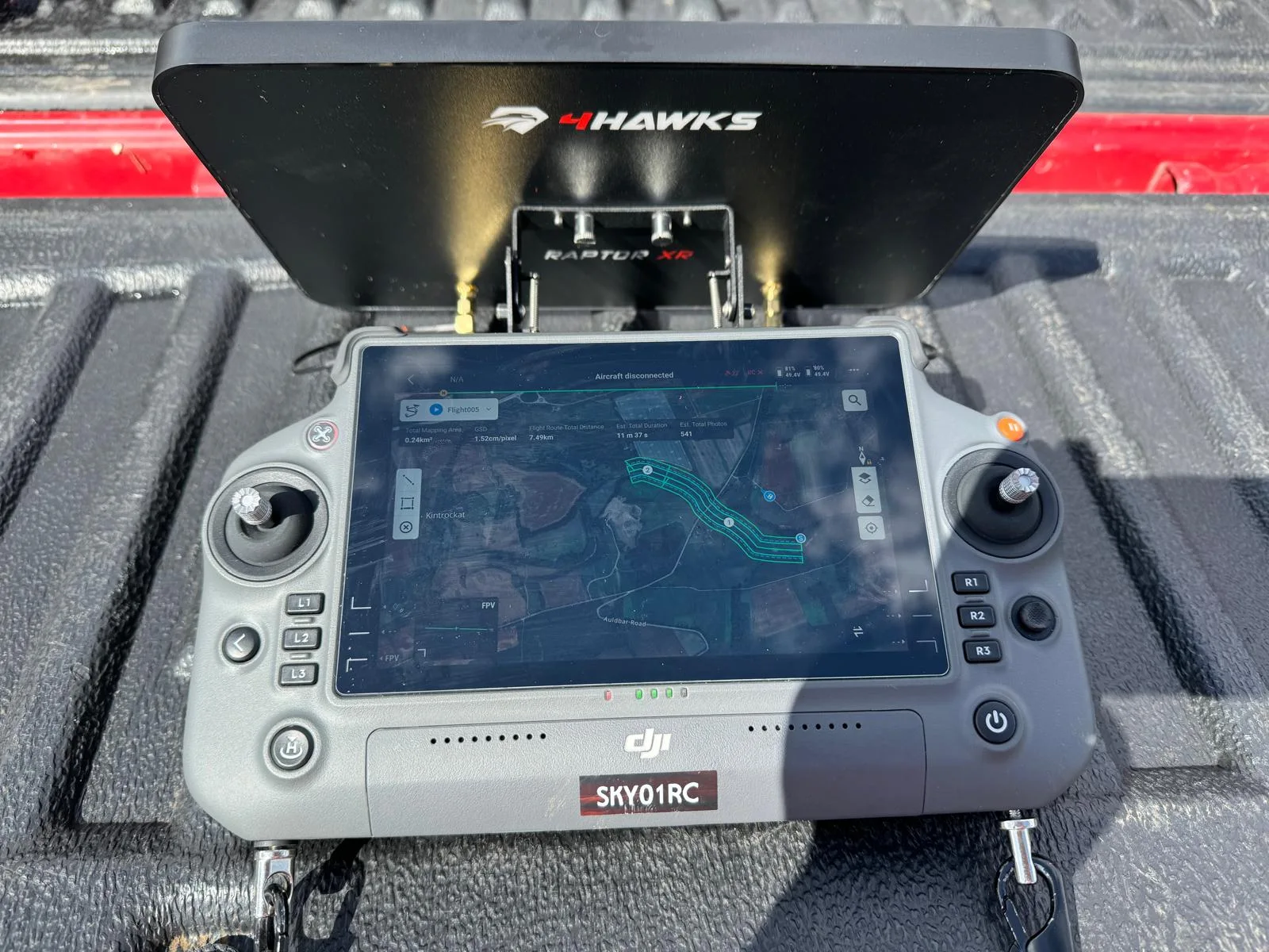
Drone corridor mapping is the process of surveying long, narrow areas—like roads, railways, pipelines, or powerlines—using UAVs equipped with cameras, LiDAR, or other sensors. The drone flies along the length of the corridor, capturing high-resolution imagery or spatial data from above.
his data is processed into detailed maps or 3D models that show the condition, alignment, and surroundings of the corridor. It helps in monitoring infrastructure, planning maintenance, and detecting issues like encroachments or vegetation overgrowth.
Compared to traditional ground surveys, drone corridor mapping is faster, safer, and more cost-effective, especially over long distances or difficult terrains. This method ensures accurate, up-to-date information for effective infrastructure management.
How Our Drone Corridor Mapping Service Work
Our drone corridor mapping process begins with a thorough route assessment and specialized flight planning to capture your linear assets efficiently. We deploy custom-equipped drones with advanced linear mapping sensors that methodically collect high-resolution data along pipelines, roads, transmission lines, or other corridor infrastructure. The captured data undergoes rigorous processing to generate detailed 3D corridor models that precisely document all critical infrastructure elements within your asset corridor.

Comprehensive route assessment and flight planning
Before any drone takes flight, we conduct a thorough assessment of your desired corridor route to identify optimal flight paths and potential challenges. We analyze topographical data, aerial obstacles, weather patterns, and regulatory restrictions to ensure safe, efficient operations.
Our team then develops customized flight plans that maximize data collection while minimizing flight time. We’ll determine ideal flight altitudes, speeds, and sensor configurations based on your specific corridor mapping needs.
We also implement contingency planning for each mission, establishing emergency landing zones and alternate routes if unexpected conditions arise. Our comprehensive approach considers everything from battery management to data processing requirements, ensuring we deliver accurate corridor mapping results every time.
Specialized drone deployment with linear mapping capabilities
With flight plans finalized, we deploy our specialized drone fleet equipped with advanced linear mapping technology. Our drones utilize RTK GPS positioning for centimeter-level accuracy while maintaining consistent altitudes along corridors regardless of terrain variations.
We’ve customized our aircraft with high-resolution linear scanners that capture continuous data strips along pipelines, transmission lines, and transportation corridors. These systems simultaneously collect RGB imagery, LiDAR, and thermal data in a single pass, providing complete corridor visibility.
Our pilots monitor operations in real-time, ensuring the drones maintain precise flight paths while adjusting for unexpected obstacles or weather conditions. The onboard AI assists with obstacle avoidance and optimal speed adjustments to maintain image quality.
Data streams directly to our mobile processing units, where initial quality checks confirm complete coverage before our team leaves the field.


Efficient data capture of extended linear features
Three key innovations drive our efficient data capture of extended linear features. First, our UAVs utilize adaptive flight patterns that automatically adjust altitude and speed based on terrain complexity, ensuring optimal resolution while maximizing coverage distance per battery cycle.
Second, we’ve developed specialized linear stitching algorithms that seamlessly blend overlapping images captured along corridors, eliminating the distortion common in traditional photogrammetry when mapping narrow, extended features like pipelines or roads.
Third, our real-time data verification system continuously monitors image quality and coverage completeness during flight, immediately flagging gaps or quality issues for on-the-spot remediation.
These technologies work together to reduce field time by up to 40% compared to conventional drone mapping methods, while delivering more accurate, comprehensive data of your linear assets.
Advanced processing and corridor model generation
Once raw corridor data is captured, our advanced processing pipeline transforms it into precise 3D models through a multi-stage workflow. We begin with photogrammetry techniques that stitch together thousands of overlapping images to create initial point clouds. Next, our proprietary algorithms clean and classify these points, removing noise and identifying key features like vegetation, structures, and ground surfaces.
We then generate detailed digital elevation models (DEMs) and orthomosaics with centimeter-level accuracy. For utility corridors, we automatically extract power line clearances and identify potential hazards. Transportation corridors benefit from our cross-section analysis tools that highlight drainage issues or structural anomalies.
All deliverables are optimized for integration with your existing GIS or CAD systems, providing immediately actionable intelligence for maintenance planning or expansion projects.

Detailed mapping products with infrastructure elements
Our comprehensive mapping products deliver far more than basic overhead imagery, incorporating detailed infrastructure elements essential for complete corridor analysis. We identify and classify all assets along your route including power lines, poles, equipment attachments, and right-of-way vegetation with centimeter-level precision.
Each deliverable includes georeferenced orthomosaics, digital surface models (DSMs), and 3D point clouds that clearly visualize every infrastructure component. We’ll highlight potential encroachments, measure clearances, and document structural conditions. For utility clients, we provide specialized products showing conductor sag, pole tilt, and vegetation risk zones.
Our mapping packages come in standard formats compatible with GIS, CAD, and asset management systems, ensuring seamless integration with your existing workflows and databases for immediate operational use.
Benefits of Drone Corridor Mapping
Our drone corridor mapping services offer five crucial advantages that transform infrastructure management. We’ll help you rapidly assess extensive linear assets with comprehensive documentation while keeping your team safe from dangerous inspection areas. You’ll benefit from consistent data quality across your entire corridor and save significantly compared to traditional survey methods.


Rapid assessment of extensive linear infrastructure
The extensive network of linear infrastructure that spans across regions demands swift monitoring solutions, and drone corridor mapping delivers exactly that. We can assess hundreds of miles of pipelines, railways, or power lines in days rather than weeks with our drone fleet.
Our drones capture high-resolution imagery and data along the entire corridor, identifying potential issues like erosion, vegetation encroachment, or structural anomalies. This rapid assessment capability means you’ll detect problems before they escalate into costly failures.
Unlike traditional ground-based inspections, we don’t need to navigate difficult terrain or secure multiple access permissions. Our drones fly systematically along predetermined routes, collecting consistent data regardless of ground conditions. This approach significantly reduces assessment time while improving safety by keeping personnel away from hazardous areas.
Comprehensive documentation of corridor conditions
Complete documentation forms the foundation of effective corridor management, giving you unprecedented insight into your infrastructure’s current state. Our drones capture high-resolution imagery and data to document every aspect of your corridors, from physical structures to vegetation encroachment.
We don’t just deliver scattered images—we provide organized, georeferenced documentation that integrates seamlessly with your existing GIS systems. This comprehensive approach lets you visualize your entire corridor network with millimeter-level precision, identifying subtle changes that ground surveys often miss.
The resulting documentation serves as both a baseline for future comparisons and a detailed inventory of assets. You’ll have access to a digital twin of your corridor infrastructure that stakeholders can remotely inspect, measure, and analyze without costly field visits. This reduces decision-making time and improves maintenance planning across your network.

Safe inspection of dangerous or inaccessible areas
Traditional inspection methods expose personnel to significant hazards when accessing remote transmission towers, bridges spanning ravines, or deteriorating infrastructure. Our drone technology eliminates these risks entirely by replacing human climbers with unmanned aerial vehicles.
We can now inspect areas that were previously considered too dangerous or physically inaccessible, such as high-voltage lines, unstable structures, and confined spaces. Our drones navigate tight corridors and challenging environments with precision, capturing high-resolution data without putting anyone in harm’s way.
This safety advantage doesn’t compromise quality. In fact, our drones often capture more comprehensive data than traditional methods because they can maneuver into positions human inspectors simply can’t reach. The result? Better information for your decision-making while protecting your team from unnecessary risks.
Consistent data quality across entire corridor length
Unlike manual inspections that often produce inconsistent results, our drone corridor mapping delivers uniform data quality from start to finish. We use standardized flight paths and automated data collection protocols to ensure every meter of your corridor receives identical scanning attention.
Our drones maintain consistent altitude, speed, and camera settings throughout the entire mission. This eliminates the quality variations typically seen when human inspectors become fatigued or rush through sections. The result? Reliable data that’s perfectly comparable across all segments of your corridor.
We’ve also implemented rigorous quality control algorithms that automatically flag any anomalies in the captured imagery. This means you’ll receive a complete dataset with uniform resolution, lighting, and perspective – making analysis and decision-making significantly more accurate and efficient.


Cost-effective alternative to traditional methods
Reevaluating your budget allocation for corridor inspection can reveal significant cost savings when you switch to our drone mapping service. We eliminate the need for expensive helicopters, ground crews, and time-consuming manual surveys that traditionally drive up costs.
Our drones capture the same data in less time, reducing labor expenses by up to 70%. You’ll also save on equipment mobilization costs since our compact systems deploy quickly anywhere along your corridor.
We’ve designed pricing tiers that scale with your project needs—pay only for the corridor length you need mapped. With no safety risks requiring additional insurance or safety personnel, you’ll cut indirect costs too. The digital deliverables we provide are immediately usable, eliminating post-processing expenses that further stretch traditional mapping budgets.
Drone Corridor Mapping Services We Offer
Our comprehensive drone corridor mapping services span critical infrastructure networks across multiple sectors. We offer specialized solutions for Pipeline Right-of-Way Mapping, Transmission Line Documentation, Railway Infrastructure Mapping, Highway Network Assessment, and River Corridor Analysis. Each service utilizes advanced drone technology to deliver precise, actionable data that enhances your infrastructure management capabilities.

Pipeline Right-of-Way Mapping
Pipeline right-of-way mapping represents one of our most valuable services for energy infrastructure clients. We use advanced drone technology to create detailed aerial surveys of pipeline corridors, capturing high-resolution imagery and precise geospatial data.
Our drones efficiently document the entire ROW width, identifying encroachments, vegetation issues, and potential hazards that threaten pipeline integrity. We’ll deliver orthorectified images, 3D models, and comprehensive GIS datasets that integrate seamlessly with your existing systems.
This service helps you maintain regulatory compliance while reducing traditional survey costs by up to 60%. We’ve mapped over 5,000 miles of pipeline corridors across diverse terrains and environments. Our rapid deployment team can respond to your mapping needs within 48 hours, ensuring you’ll always have current, actionable data for critical infrastructure decisions.
Transmission Line Corridor Documentation
Beyond pipeline infrastructure, transmission line corridors present unique monitoring challenges that we’ve mastered through specialized drone mapping techniques. Our high-resolution aerial photography captures every tower, insulator, and line with precision impossible from ground surveys.
We identify encroachments, vegetation threats, and structural issues along your entire transmission network. Our thermal imaging reveals hot spots before they become failures, while LiDAR generates accurate clearance measurements between conductors and surrounding objects.
After each flight, you’ll receive comprehensive digital maps showing corridor conditions with centimeter-level accuracy. These deliverables integrate seamlessly with your GIS systems, enabling better maintenance planning and regulatory compliance.
With our transmission corridor documentation, you’ll dramatically reduce inspection costs while improving reliability and safety across your power distribution network.


Railway Track and Infrastructure Mapping
While traditional railway inspection methods require track closures and personnel on the ground, our drone mapping service revolutionizes infrastructure monitoring for the rail industry. We capture detailed imagery of tracks, bridges, tunnels, and signal equipment without disrupting operations.
Our drones collect millimeter-precise data that identifies rail wear, gauge issues, vegetation encroachment, and structural concerns before they become safety hazards. We’ll deliver comprehensive 3D models and orthomosaic maps that your maintenance teams can access instantly.
We’re helping railway operators reduce inspection costs by up to 60% while improving safety outcomes. You’ll receive actionable intelligence about track conditions, enabling predictive maintenance rather than reactive repairs. This means fewer service disruptions and extended infrastructure lifespan for your entire railway network.
Highway and Road Network Assessment
Our highway and road network assessment service provides transportation authorities with unprecedented access to infrastructure data without traffic disruption. We use specialized drones to capture high-resolution imagery that identifies pavement deterioration, lane markings, guardrails, and roadside hazards requiring attention.
Our team processes collected data to create detailed condition reports that prioritize maintenance needs. We’re able to assess miles of roadway in a fraction of the time required by ground crews, resulting in cost savings of up to 60% compared to traditional methods.
We’ll identify drainage issues, detect thermal variations indicating subsurface problems, and monitor traffic patterns to optimize flow. Our regular assessment schedules help transportation departments transition from reactive to preventative maintenance, extending infrastructure lifespan and improving safety for all road users.

River and Waterway Corridor Analysis
Rivers and waterways present unique mapping challenges that our specialized drone services address with precision and efficiency. Our drones capture high-resolution imagery of meandering waterways, monitoring erosion patterns, vegetation encroachment, and sediment buildup that can affect water flow.
We’re equipped to identify flood-prone areas by creating detailed elevation models that reveal potential overflow zones. Our thermal imaging capabilities detect underground springs, pollution sources, and temperature variations that impact aquatic ecosystems.
For infrastructure management, we thoroughly document bridges, dams, levees, and water control structures along waterways. This comprehensive data helps planners prioritize maintenance efforts and develop effective flood mitigation strategies. We’ll deliver actionable insights about your waterway corridors in formats compatible with your existing GIS systems.
Utility Infrastructure Documentation
Because utility networks represent critical infrastructure that spans vast territories, our drone mapping solutions provide comprehensive documentation that traditional methods cannot match. We capture high-resolution imagery of power lines, pipelines, telecom networks, and renewable energy installations with millimeter precision.
Our drones efficiently inspect transmission towers, identify vegetation encroachment, and detect damaged components without service interruptions. We’ll deliver detailed 3D models of your utility corridors that highlight clearance issues and potential hazards before they become problems.
We’ve helped utility companies reduce inspection costs by up to 70% while increasing data quality. Our thermal imaging capabilities can identify hotspots on electrical components, allowing for targeted maintenance that prevents costly failures and service disruptions.


Encroachment and Vegetation Monitoring
Why risk costly line damage or service disruptions when regular vegetation monitoring can prevent them? Our drone corridor mapping identifies potential hazards before they impact your infrastructure.
We detect tree growth patterns that threaten power lines, spot unauthorized construction encroaching on right-of-ways, and monitor seasonal vegetation changes. Our high-resolution imagery captures even subtle shifts in corridor conditions.
We’ll provide you with comprehensive reports highlighting areas of concern with GPS coordinates and severity ratings. This allows your maintenance crews to prioritize trimming operations and address encroachments promptly.
Erosion and Environmental Impact Assessment
Delicate watershed areas surrounding utility corridors often face erosion threats that can undermine infrastructure stability. Our drone surveys detect early signs of soil displacement, water channeling, and land degradation before they become costly emergencies.
We’ll identify vulnerable slopes and drainage patterns using high-resolution imagery combined with specialized erosion analysis software. This allows us to pinpoint areas requiring immediate remediation and predict future trouble spots based on topographical data.
Our environmental impact assessments go beyond erosion to document habitat disruption, invasive species spread, and water quality concerns. We provide comprehensive reports that satisfy regulatory requirements while offering practical solutions for environmental stewardship.

Technology We Use for Drone Corridor Mapping
Our drone corridor mapping services rely on three cutting-edge technologies that work in concert to deliver precise results. First, we utilize LiDAR sensors capable of capturing millions of points per second with centimeter-level accuracy, even in dense vegetation. These sensors work alongside our high-resolution multispectral cameras that capture both visible light and near-infrared data, revealing terrain features invisible to the naked eye.
The final component is our proprietary data processing software that transforms raw data into actionable 3D models and analytics. We’ve integrated AI algorithms that can automatically identify potential hazards, changes in topography, and vegetation encroachment along corridors. Our drones themselves feature RTK GPS positioning and autonomous flight capabilities, ensuring consistent coverage regardless of terrain complexity or weather conditions.
Applications Across Infrastructure Types
We’ve successfully deployed our drone corridor mapping services across a diverse range of critical infrastructure systems. Our mapping solutions provide comprehensive data for oil and gas pipelines, electrical transmission networks, transportation corridors, water management systems, and telecommunications infrastructure. These varied applications demonstrate our technology’s adaptability and effectiveness in monitoring, maintaining, and optimizing infrastructure regardless of its purpose or physical environment.


Oil and gas pipelines
The intricate network of oil and gas pipelines requires constant monitoring to prevent leaks, corrosion, and structural failures. Our drones conduct comprehensive surveys along these critical infrastructure corridors, capturing high-resolution imagery and thermal data that identify potential issues before they become catastrophic.
We’ve developed specialized detection algorithms that spot even minor temperature variations, ground disturbances, and vegetation changes—all potential indicators of pipeline problems. Our clients receive detailed reports highlighting areas of concern with precise GPS coordinates for immediate investigation.
The efficiency of our drone mapping reduces inspection times by up to 80% compared to traditional ground crews, while significantly improving safety by eliminating the need for personnel to access remote or hazardous locations. We’re proud to help maintain the integrity of vital energy transportation systems across the country.
Electrical transmission networks
Thousands of miles of electrical transmission lines crisscross the country, creating a vulnerable network that’s essential to our national power grid. Our drone services provide power companies with comprehensive monitoring of these critical assets at a fraction of traditional inspection costs.
We’ll identify potential hazards such as encroaching vegetation, damaged insulators, or structural weaknesses before they cause outages. Our thermal imaging can detect hotspots indicating failing components or connections, while our LiDAR mapping creates precise digital models of transmission corridors.
During emergencies, we’ll quickly assess storm damage to prioritize repair efforts effectively. The data we collect helps utilities optimize maintenance schedules, reduce risks, and improve reliability for customers. We’re also helping companies meet regulatory compliance requirements through detailed documentation and regular inspection reports.

Transportation corridors
Transportation networks spanning highways, railways, and bridges require constant monitoring to ensure public safety and operational efficiency. Our drones deliver comprehensive views of these vital corridors, helping you identify potential hazards before they become problems.
We’ll map traffic flow patterns, detect road surface deterioration, and inspect bridge integrity with millimeter precision. For railways, we can identify track deformations, vegetation encroachment, and security vulnerabilities along the entire route.
What once took weeks of ground-based inspections can now be completed in hours. Our thermal imaging capabilities can even detect subsurface structural weaknesses not visible to the naked eye. The data we provide helps you prioritize maintenance resources efficiently while minimizing disruption to travelers. You’ll receive actionable intelligence that supports both immediate intervention and long-term infrastructure planning.
Water management systems
Rivers, reservoirs, stormwater systems, and watersheds form complex networks that demand vigilant monitoring for both flood prevention and water quality management. Our drone corridor mapping services excel in these aquatic environments, where traditional surveys often prove difficult and dangerous.
We’ll map entire river systems to identify erosion hotspots, document changing flow patterns, and detect problematic debris buildup. For reservoirs and dams, we provide detailed structural assessments that reveal potential weaknesses before they become critical.
Our specialized sensors detect pollutants in waterways, helping you pinpoint contamination sources. We’ll also create comprehensive stormwater infrastructure maps showing culvert conditions, drainage patterns, and potential flood zones—data that’s invaluable for maintenance planning and emergency response.
With our water corridor mapping, you’ll gain actionable insights for smarter resource management decisions.


Telecommunications infrastructure
As the backbone of our digital society, telecommunications networks require meticulous mapping to ensure optimal performance and coverage. Our drones excel at identifying signal tower locations, mapping fiber optic routes, and detecting potential interference obstacles.
We’ll help you visualize network coverage patterns by creating 3D models that highlight dead zones and signal strength variations across different terrains. This data proves invaluable when planning new tower placements or optimizing existing infrastructure.
Our thermal imaging capabilities can also identify overheating equipment or power inefficiencies before they cause service disruptions. We’ve helped numerous telecom companies reduce maintenance costs by 30% through early detection of potential failures.
Environmental monitoring zones
When establishing environmental monitoring zones, our drones provide comprehensive data collection that transforms how organizations track ecological changes over time. We map sensitive habitats, wetlands, and protected areas with centimeter-level precision while minimizing ground disturbance.
Our corridor mapping identifies erosion patterns, vegetation changes, and wildlife movements that might go undetected through traditional surveys. We’ll customize flight paths to regularly monitor air and water quality indicators along industrial corridors or conservation areas.
Clients appreciate how we integrate thermal, multispectral, and LiDAR sensors to create baseline environmental conditions and detect subtle changes. This data helps environmental compliance officers make evidence-based decisions and demonstrate regulatory adherence. It’s particularly valuable for long-term impact assessments of infrastructure projects in ecologically sensitive regions.

Why Choose Our Drone Corridor Mapping Team
Since our establishment in 2015, we’ve built an unparalleled reputation for excellence in corridor mapping technology. Our certified team combines technical expertise with practical field experience across diverse environments—from dense urban areas to remote wilderness.
We’re equipped with the latest UAV technology, including LiDAR sensors and multispectral cameras that capture millimeter-precise data. Our proprietary analytics software transforms raw data into actionable insights within 48 hours, far exceeding industry standards.
We’ve completed over 300 corridor mapping projects for utilities, transportation agencies, and environmental firms with a 99.7% client satisfaction rate. Our team’s commitment to safety is reflected in our perfect regulatory compliance record and zero incidents across 8,000+ flight hours.
Contact Us For Your Drone Corridor Mapping Needs
Ready to optimize your linear infrastructure management with comprehensive aerial data? Our specialized drone corridor mapping services provide detailed visual documentation, precise measurements, and condition assessments for railways, pipelines, power lines, roads, and other corridor assets.
Reach out today through our dedicated infrastructure line at +44 7368 537499 or email us at Jamie@skykam.co.uk. We’ll respond within 24 hours to schedule your free consultation.
When contacting us, please include information about your corridor type, length, and specific monitoring objectives. This helps us plan the most efficient survey approach for your linear assets. We serve utility companies, transportation authorities, and infrastructure managers throughout the UK with minimal disruption to operations.
Let’s collaborate to enhance your corridor maintenance strategy with actionable insights from our advanced drone mapping technology.