Need to inspect hard-to-reach culverts or sewer systems without the risk, expense, and disruption of confined space entry?
Our specialised Drone culvert and sewer survey service provides crystal-clear visual data of your drainage infrastructure without sending personnel into potentially hazardous environments.
We can quickly identify blockages, structural issues, and maintenance needs—all while your systems remain operational.
Used By Top UK Businesses

👇Fill Out The Form For Same-Day Drone Survey Quote 👇
Why Leading UK Businesses Choose Our Drone Survey Services:
✅ We’re Fully Licensed, Insured Drone Pilots
✅ We Cover the UK with Fast Response Times
✅ We Only Use Top-Quality Drone Equipment
✅ We Customize Solutions for Your Industry
✅ We Handle All the Paperwork and Permissions
✅ We Have Worked with Hundreds of Happy Customers


What Is Drone Culvert Inspection?
Drone culvert inspection is a specialized service that uses advanced unmanned aerial vehicles (UAVs) to assess the condition of water drainage structures without requiring personnel to physically enter these confined spaces.
These drones are equipped with high-definition cameras, LED lighting systems, and sometimes LiDAR or sonar technology to navigate through culverts, pipes, and drainage channels, capturing detailed imagery of the interior surfaces.
The drones systematically document structural issues such as cracks, corrosion, sediment buildup, blockages, joint separations, and erosion problems that might compromise the culvert’s integrity or functionality.
This method eliminates the safety risks associated with confined space entry while providing comprehensive visual data on conditions that might otherwise remain undetected.
After inspection, engineers analyze the collected footage and data to create detailed assessment reports that identify maintenance priorities, recommend repairs, and help prevent catastrophic failures.
Drone culvert inspections are particularly valuable for transportation departments, municipalities, and property managers responsible for stormwater management infrastructure, offering a faster, safer, and more cost-effective alternative to traditional manual inspection methods.


How Our Drone Culvert and Sewer Surveys Work
Our drone culvert and sewer surveys follow a systematic five-stage process, beginning with a thorough assessment of your drainage system to develop a tailored survey plan.

Initial assessment and survey planning
Before we initiate any drone survey of culverts or sewers, we conduct a thorough initial assessment to gather essential information about the site. This involves evaluating access points, measuring structure dimensions, and identifying potential hazards that might impact our drone operation.
Our planning process includes:
- Reviewing any existing documentation or previous surveys
- Assessing environmental factors like water flow and ventilation
- Determining the optimal drone configuration for the specific conditions
- Creating a detailed flight path that ensures complete coverage
- Establishing safety protocols and contingency plans
We’ll also coordinate with your facility managers to schedule the survey during low-flow periods whenever possible.
This preparation ensures we capture high-quality footage while minimizing disruption to your operations and maintaining compliance with relevant regulations.

Specialized drone deployment into drainage systems
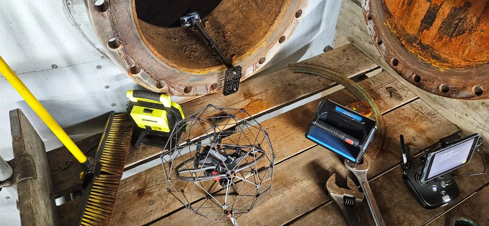
Following our thorough initial assessment, we execute the deployment phase with precision and specialized equipment. Our waterproof drones are fitted with high-definition cameras, LED lighting systems, and protective casings designed specifically for confined spaces.
We carefully lower each drone through access points, maintaining constant communication via tethered connections that ensure uninterrupted data transmission and prevent signal loss underground.
Our pilots navigate the confined spaces using real-time video feeds, documenting structural defects, blockages, and water infiltration points.
For larger culverts, we employ specialized crawler drones that move along the invert, providing stable footage of the entire circumference. In smaller pipes, we use custom-built micro drones with flexible chassis that can maneuver through tight bends while maintaining image quality and positional accuracy.


High-definition video and image capture
Every inspection relies on our cutting-edge camera systems that capture 4K ultra-high-definition video and 20-megapixel still images of culvert and sewer interiors. These crystal-clear visuals reveal even the smallest defects, from hairline cracks to subtle joint displacements that standard inspection methods often miss.
We’ve equipped our drones with powerful LED lighting systems that illuminate the darkest corners of underground infrastructure. This combination of advanced optics and lighting allows us to document structural conditions with unprecedented detail.
All footage is georeferenced and timestamped, creating a comprehensive digital record that engineers can review repeatedly without requiring additional site visits.
We also generate detailed condition reports that pinpoint exactly where issues exist, making it easier to plan targeted repairs rather than costly wholesale replacements.
Data processing and analysis
Once our drones complete their inspection flights, we transform the raw footage into actionable intelligence through our comprehensive data processing pipeline. We use specialized software to stitch together thousands of high-resolution images, creating detailed 3D models of your culvert or sewer system.
Our analysts then examine these models to identify structural defects, blockages, erosion, and other issues. We classify each problem according to industry-standard condition codes and severity ratings. This systematic approach allows us to prioritize maintenance needs based on critical factors.
You’ll receive a detailed report with precise measurements, georeferenced anomalies, and recommended actions. We can also integrate our findings into your existing GIS or asset management systems, ensuring seamless incorporation into your maintenance workflow.

Detailed condition reporting and recommendations
Our comprehensive condition reporting delivers immediate, actionable insights about your infrastructure’s health. We identify critical issues like structural damage, blockages, sediment buildup, and potential failure points with precise location data and severity ratings.
Each report includes high-resolution imagery, detailed damage metrics, and color-coded severity maps that pinpoint areas requiring urgent attention. We’re not just documenting problems—we’re providing solutions through tailored maintenance recommendations and repair priorities.
Our engineers analyze flow capacity restrictions, deterioration patterns, and structural integrity to create practical remediation strategies. We’ll help you develop targeted maintenance schedules that maximize your budget while minimizing disruption to operations. This proactive approach prevents costly emergency repairs and extends infrastructure lifespan, saving you significant resources in the long term.
Benefits of Drone Culvert and Sewer Surveys
Our drone culvert and sewer surveys deliver multiple advantages that traditional methods simply can’t match. We’ve eliminated confined space entry risks while providing rapid assessments of extensive drainage networks with minimal service disruption. You’ll receive complete visual documentation for maintenance planning at a cost significantly lower than conventional CCTV approaches.


Elimination of confined space entry risks
Perhaps the most significant advantage of drone culvert and sewer surveys is the complete elimination of confined space entry risks for inspection teams. Traditional inspections require personnel to physically enter hazardous environments with poor ventilation, toxic gases, and flash flood risks.
Our drones navigate these dangerous spaces instead of humans, keeping our staff safely above ground while still capturing high-quality data. We’ve eliminated the need for specialized training, safety equipment, and rescue teams on standby during inspections. The psychological burden on workers is also removed – no one has to face the anxiety of entering dark, cramped passages.
Rapid assessment of extensive drainage networks
Whereas traditional inspection methods might take weeks to cover large drainage networks, drone technology enables comprehensive surveys of entire systems in just days or even hours. This dramatic reduction in survey time translates to significant cost savings for our clients while providing faster access to critical infrastructure data.
Our drones can quickly navigate through kilometers of drainage networks, capturing high-resolution imagery and data that would be impossible to collect manually in such timeframes. We’re able to identify problem areas, prioritize maintenance needs, and develop remediation plans with unprecedented speed.
For municipalities and property managers overseeing complex drainage systems, this rapid assessment capability means they can be more proactive about maintenance and respond faster to potential issues before they become costly emergencies.

Minimal service disruption during inspections
Unlike conventional inspection methods that often require service interruptions, drone-based culvert and sewer surveys can be conducted while systems remain fully operational. This means businesses, residents, and traffic flows experience minimal inconvenience during our inspection processes.
Our drones navigate through existing access points without the need for extensive setup or excavation work. We don’t need to implement costly bypass pumping operations or flow diversions that traditional manual inspections require. This approach eliminates the community disruption caused by road closures, traffic detours, and service suspensions.
For municipalities and utility companies, this translates to significant cost savings and improved public relations. We’re able to gather comprehensive data without interrupting essential services, keeping your community running smoothly while still obtaining the critical infrastructure information you need.
Complete visual documentation for maintenance planning
When planning effective maintenance strategies, complete visual documentation serves as the cornerstone of informed decision-making. Our drone surveys provide comprehensive visual records of your entire culvert and sewer infrastructure, capturing high-resolution imagery from multiple angles that human inspectors simply cannot match.
We’ll deliver detailed footage of structural conditions, defects, sediment buildup, and potential blockage points—all organized into accessible formats for your maintenance team. These visual assets allow you to prioritize repairs based on actual conditions rather than assumptions, allocate resources efficiently, and develop preventative maintenance schedules.
Unlike traditional methods that might miss critical areas, our drones create a continuous visual narrative that eliminates guesswork. This complete documentation becomes your reference point for tracking deterioration over time and justifying budget requests for necessary infrastructure improvements.


Cost-effective alternative to traditional CCTV methods
Traditional CCTV inspection methods come with significant costs that our drone survey technology effectively eliminates. We’ve reduced the need for specialized vehicles, extensive human entry, and traffic disruption that drive up conventional inspection prices.
Our drones deploy quickly, requiring just a two-person team versus the larger crews needed for CCTV operations. There’s no need for costly bypass pumping systems in many scenarios, as our drones can navigate partially flowing culverts and sewers.
You’ll see immediate savings on mobilization costs and enjoy faster turnaround times on reports. Since we capture comprehensive HD footage in a single visit, you’ll avoid the repeat inspections often necessary with traditional methods. Our drone surveys typically save clients 30-50% compared to conventional CCTV inspection approaches.
Drone Culvert and Sewer Survey Services We Offer
We offer comprehensive drone services including detailed Structural Condition Assessments that identify cracks, corrosion, and deterioration before they become critical failures. Our Blockage and Flow Assessment capabilities detect obstructions and monitor water movement, while our Preventative Maintenance Support helps clients develop cost-effective upkeep schedules. For urgent situations, our Emergency Response Surveys provide rapid evaluations of damage following storms, floods, or unexpected structural issues.

Structural Condition Assessment
Assessing the structural integrity of culverts and sewers requires specialized expertise that our drone survey teams deliver efficiently and safely. Our drones capture high-resolution images and video of critical structural elements, identifying cracks, fractures, joint separations, and material deterioration often missed by traditional inspection methods.
We evaluate load-bearing capacity, assess settlement issues, and document corrosion severity to prioritize maintenance needs. Our thermal imaging capabilities detect hidden water infiltration and structural weaknesses before they become catastrophic failures.
After each assessment, we provide comprehensive reports with detailed structural ratings, photographic evidence, and recommended remediation actions. This data-driven approach helps you develop cost-effective maintenance strategies that extend infrastructure lifespan while ensuring public safety and regulatory compliance.
Blockage and Flow Assessment
When culverts and sewers become obstructed, our drone technology provides unmatched visibility into blockage issues that can cause flooding or structural damage. Our specialized drones can identify accumulations of debris, sediment buildup, tree root intrusions, and other flow impediments that traditional inspection methods might miss.
We’ll assess water flow patterns to pinpoint areas of concern, even in partially submerged conditions. Using high-definition video and thermal imaging, we can detect hidden blockages before they escalate into emergency situations. This proactive approach helps municipalities and property managers prioritize maintenance needs and prevent costly failures.
Our detailed blockage reports include location mapping, obstruction characterization, and severity ratings, giving you actionable data to address flow issues efficiently and maintain optimal drainage system performance.


Preventative Maintenance Support
Rather than waiting for problems to develop, our preventative maintenance drone surveys help infrastructure managers stay ahead of potential issues. We create comprehensive maintenance schedules based on real-time data, identifying early signs of deterioration before they become costly emergencies.
Our drones detect hairline cracks, minor sediment buildup, and early-stage corrosion that might be missed during traditional inspections. We’ll establish baseline conditions of your culverts and sewers, then conduct regular comparative assessments to track changes over time.
This proactive approach significantly reduces emergency repair costs and extends infrastructure lifespan. By identifying minor issues early, you’ll avoid service disruptions and protect surrounding environments from potential contamination. We’ll work with your team to develop customized preventative maintenance protocols based on our detailed drone findings.
Emergency Response Surveys
Our emergency response drone surveys provide rapid assessment capabilities when disaster strikes. When flooding, structural failures, or blockages occur, we’ll deploy drones within hours to identify the extent of damage without putting inspection teams at risk.
Our thermal imaging and high-definition cameras can locate breach points, assess structural integrity, and map flooded areas that would be inaccessible by traditional methods. This allows municipal teams to prioritize resources and develop targeted repair strategies immediately.
We transmit real-time footage directly to emergency management teams, enabling faster decision-making during critical incidents. By eliminating the need for confined space entry during hazardous conditions, we’re helping communities respond more safely and effectively to infrastructure emergencies while potentially saving lives and reducing recovery costs.

Technology We Use for Culvert and Sewer Surveys
To conduct comprehensive culvert and sewer surveys, we’ve invested in specialized drone technology that’s specifically engineered for confined space inspection. Our fleet includes collision-tolerant drones equipped with powerful LED lighting systems and 4K cameras that capture high-resolution imagery even in complete darkness.
We utilize tethered drone systems for deeper inspections, ensuring uninterrupted power supply and real-time data transmission. Our drones feature waterproof housings that protect sensitive components from moisture and debris while navigating through culverts.
For data processing, we employ advanced photogrammetry software that creates detailed 3D models of inspected structures, allowing us to identify structural deficiencies with millimeter precision. Our thermal imaging capabilities detect hidden water infiltration and temperature anomalies that might indicate structural weaknesses or blockages.
Types of Infrastructure We Survey
We survey a diverse range of drainage infrastructure including storm water culverts, municipal sewer systems, and highway drainage networks. Our drone technology effectively accesses and assesses industrial drainage networks that often present challenging entry points for traditional inspection methods. We’ve also adapted our survey capabilities to support agricultural drainage systems, helping farmers maintain effective water management across their properties.


Storm water culverts
Storm water culverts play a critical role in managing water flow and preventing flooding across urban and rural landscapes. These underground passages redirect rainwater and runoff away from roads, buildings, and critical infrastructure.
We’ve specialized in surveying culverts of all sizes—from small roadway drainage pipes to massive concrete boxes beneath highways. Our drones navigate through these confined spaces, capturing high-resolution imagery and detailed measurements that would be difficult or dangerous for human inspectors to obtain.
Our culvert surveys identify blockages, structural damage, sediment buildup, and unwanted vegetation growth—all common issues that reduce capacity and effectiveness. We’ll document joint separations, cracks, corrosion, and deformation that might lead to failure. By detecting these problems early, we’re helping municipalities and transportation departments prioritize maintenance and avoid costly emergency repairs.
Municipal sewer systems
Municipal sewer systems represent the hidden backbone of urban sanitation, stretching for thousands of miles beneath our cities. These complex networks demand regular inspection to prevent costly failures and environmental hazards, which is where our drone technology excels.
We’ve optimized our drones for navigating the unique challenges of municipal sewers, including confined spaces, poor lighting, and potentially hazardous gases. Our equipment captures high-definition video and infrared imagery that reveals structural defects, blockages, infiltration points, and deteriorating connections that aren’t visible to the naked eye.

Highway drainage infrastructure
Beyond city sewers lies another expansive network requiring regular inspection—the highway drainage infrastructure that keeps our roads safe and functional. Our drones navigate the extensive system of culverts, detention basins, and roadside drainage channels that prevent flooding and erosion along highways.
We’re equipped to survey box culverts, pipe culverts, and cross drains that run beneath roadways. Our drones capture high-definition footage of structural integrity, sediment buildup, and potential blockages without disrupting traffic flow or requiring lane closures. This approach is particularly valuable for DOT agencies needing comprehensive assessments of drainage conditions across their highway networks.
Industrial drainage networks
Industrial facilities often require specialized drainage systems that must meet strict environmental compliance standards. Our drone technology easily navigates these complex networks, providing comprehensive inspections of industrial drainage infrastructure without disrupting operations.
We’re experienced in surveying chemical plant drainage systems, manufacturing facility stormwater networks, and industrial wastewater systems. Our drones capture high-resolution imagery and data of retention ponds, treatment facilities, and discharge points that help identify potential contamination sources or structural issues.
When surveying industrial settings, we’re particularly attentive to signs of chemical degradation, sediment buildup, and regulatory compliance issues. These inspections help facility managers prevent costly environmental violations while maintaining operational efficiency. Our detailed reports include actionable recommendations for maintenance, repairs, or system upgrades that align with current environmental regulations.


Agricultural drainage systems
Agricultural land requires effective drainage systems to maintain soil health and maximize crop yield, which is why our drone technology has become invaluable for farmers and land managers. We inspect tile drainage networks, irrigation channels, and retention ponds that might otherwise take weeks to assess manually.
Our drones can rapidly map large agricultural properties, identifying blockages, collapses, and deterioration in culverts that channel water beneath access roads. We’ll detect sedimentation issues in drainage ditches before they cause flooding and crop damage.
We provide comprehensive reports highlighting problem areas that need immediate attention versus those requiring monitoring. By catching drainage issues early, we help prevent waterlogged fields, nutrient leaching, and erosion—all while saving you time and resources compared to traditional inspection methods.
Flood control structures
Flood control infrastructure forms the critical backbone of community resilience against water-related disasters, which is why we prioritize these systems in our drone inspection services. Our drones efficiently assess detention basins, levees, floodwalls, dams, and stormwater channels to identify potential weaknesses before they fail.
We’ll evaluate sediment buildup, erosion patterns, vegetation encroachment, and structural integrity during our comprehensive surveys. Our high-resolution imagery captures minute cracks, displacement, and deterioration that might otherwise go unnoticed until catastrophic failure occurs.
Following heavy rainfall or flood events, we provide rapid post-event assessments to document damage and prioritize repairs. By creating detailed 3D models of your flood control systems, we help you develop proactive maintenance schedules and strengthen weak points before the next major weather event strikes.

Why Choose Our Drone Culvert and Sewer Survey Team
Three key advantages set our drone survey team apart from traditional inspection methods. First, we eliminate confined space entry risks by sending drones where humans shouldn’t go, significantly enhancing safety while reducing liability concerns for your organization.
Second, our specialized drones capture high-resolution imagery and precise measurements in a fraction of the time required for manual inspections. This efficiency translates directly to cost savings and minimal disruption to your operations.
Finally, we’re staffed by certified drone pilots with extensive hydraulic engineering backgrounds. This unique combination means we don’t just collect visual data—we interpret it professionally, delivering actionable insights about structural integrity, sediment buildup, and potential failure points.
We’ll help you transition to more efficient, safer inspection protocols that improve maintenance planning and extend infrastructure lifespan.
Contact Us For Your Drone Culvert and Sewer Survey Needs
Ready to inspect your drainage infrastructure without the risks and limitations of manual entry? Our specialized drone technology provides comprehensive visual data of culverts and sewer systems, identifying issues before they become costly problems.
Reach out today through our dedicated infrastructure line at +44 7368 537499 or email us at Jamie@skykam.co.uk. We’ll respond within 24 hours to arrange your free consultation.
When contacting us, please provide information about your drainage system’s location, dimensions, and any specific concerns you may have. This helps us prepare the right equipment and approach for your unique situation. We serve clients throughout the UK and can quickly mobilize for both scheduled maintenance inspections and emergency assessments.
Let’s collaborate to maintain your critical drainage infrastructure more safely and effectively with our advanced drone inspection technology.