Need accurate subsurface data? Save time, cut costs, and get crystal-clear insights with our advanced drone ground penetrating radar survey services.
Don’t settle for risky, time-consuming traditional methods when our enterprise-grade drone GPR technology delivers faster, safer subsurface analysis results.
As specialists in industrial-grade underground mapping and anomaly detection since 2016, we provide the actionable subsurface data you need for critical infrastructure decision-making.
Used By Top UK Businesses

👇Fill Out The Form For Same-Day Drone Survey Quote 👇
Why Leading UK Businesses Choose Our Drone Survey Services:
✅ We’re Fully Licensed, Insured Drone Pilots
✅ We Cover the UK with Fast Response Times
✅ We Only Use Top-Quality Drone Equipment
✅ We Customize Solutions for Your Industry
✅ We Handle All the Paperwork and Permissions
✅ We Have Worked with Hundreds of Happy Customers

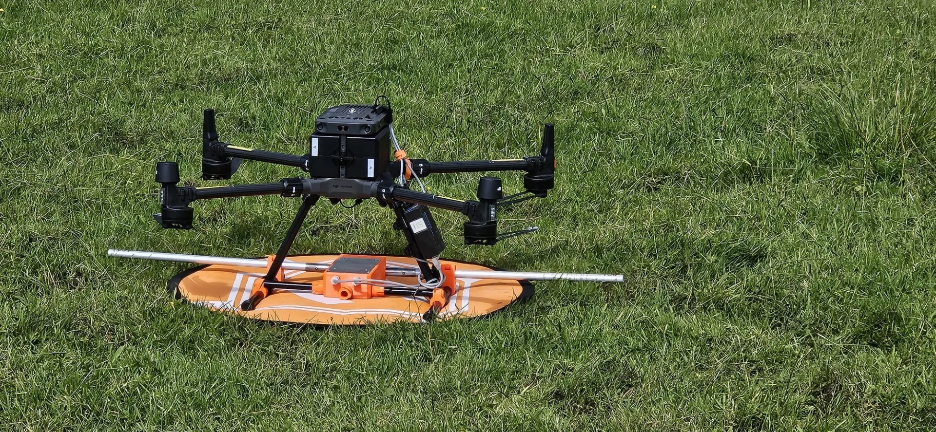
Drone Ground Penetrating Radar Survey
Advancements in surveying technology have revolutionized how we detect and map subsurface features. Our drone-mounted GPR systems combine aerial mobility with sophisticated subsurface scanning capabilities, delivering exceptional results without disturbing the terrain.
We’ve engineered our drone GPR units to penetrate various soil types and materials, detecting buried utilities, archaeological remains, voids, and geological formations up to 10 meters deep. The aerial approach allows us to survey large areas quickly or access hazardous locations that would be challenging for traditional ground surveys.
Each survey produces high-resolution 3D subsurface imaging that we process into detailed maps and reports. This data helps you make informed decisions about construction, excavation, or preservation projects while minimizing potential risks and unexpected discoveries.


What Is Drone Ground Penetrating Radar Surveying
Drone Ground Penetrating Radar (GPR) surveying represents a cutting-edge integration of aerial technology with sophisticated subsurface imaging capabilities. This innovative approach allows us to scan beneath the surface while our drones fly overhead, creating detailed maps of underground features without disturbing the soil.
We’ve engineered our systems to emit radar pulses that penetrate the ground and reflect back when they encounter different materials. These reflections are captured by sensitive receivers and processed into comprehensive 3D models of subsurface conditions. The technology excels at identifying utilities, voids, archaeological remains, and geological formations up to several meters deep.
Unlike traditional GPR methods that require ground contact, our drone-mounted systems cover large areas quickly and access difficult terrain safely, revolutionizing how subsurface investigations are conducted.
How Our Drone GPR Surveys Work
Our drone GPR survey process combines meticulous site assessment with specialized aerial deployment of ground penetrating radar equipment. We capture comprehensive subsurface data through systematic flight patterns, followed by advanced processing techniques that identify anomalies and hidden features. The final deliverable includes detailed reporting that maps all discovered subsurface elements, providing you with actionable intelligence about what lies beneath your site.

Site assessment and survey planning
Effective GPR surveys begin with a comprehensive site assessment and meticulous planning process. We start by analyzing your site’s geological conditions, identifying potential obstacles, and determining optimal flight paths for our drones. This initial evaluation allows us to select the appropriate GPR frequency ranges for your specific subsurface targets.
Our team then develops a customized survey grid that ensures complete coverage while maximizing data quality. We’ll consider factors like required resolution, depth penetration needs, and any regulatory constraints that might affect our operation. During this phase, we’ll also establish ground control points for precise georeferencing of the collected data.
This preparation work is crucial – it’s what enables us to deliver accurate, actionable subsurface insights while minimizing time in the field and potential disruptions to your operations.
Specialized drone deployment with GPR equipment
When it comes to collecting underground data, our specialized drone-mounted GPR systems represent a quantum leap in survey technology. We’ve engineered our drones to carry compact, high-resolution GPR units capable of penetrating various soil types and detecting buried objects with remarkable precision.
Our deployment process begins with calibrating the equipment to your specific site conditions. We then program autonomous flight paths that ensure complete coverage of your survey area. During flight, our drones maintain precise altitude and speed for optimal data collection, while streaming real-time feedback to our technicians.
We’ve overcome traditional GPR limitations by combining advanced drone stability systems with sophisticated signal processing algorithms. This integration allows us to survey hazardous or inaccessible areas without risking personnel safety, all while collecting higher quality subsurface data than conventional methods.


Subsurface data acquisition and collection
The advanced technology deployment described above enables our systematic approach to subsurface data acquisition. We fly our drones in precise grid patterns across your site, with the GPR continuously emitting and receiving electromagnetic pulses. These pulses penetrate the ground at depths ranging from 1-10 meters, depending on soil conditions and the specific equipment deployed.
As our drones traverse the survey area, they’re simultaneously collecting and timestamping geospatial data with centimeter-level accuracy. The onboard computers process initial readings in real-time, allowing our technicians to identify areas requiring additional passes or alternate scanning frequencies. We typically collect data at multiple frequencies to optimize both resolution and depth penetration, ensuring comprehensive subsurface mapping. The entire collection process generates terabytes of raw data that we then transfer to our processing centers for advanced analysis.
Advanced data processing and anomaly detection
Once collected, raw GPR data undergoes our proprietary multi-stage processing workflow designed to transform complex signal returns into actionable intelligence. We employ advanced signal filtering algorithms to remove noise while preserving critical subsurface signatures that might indicate utilities, voids, or structures.
Our team uses machine learning models trained on thousands of verified anomalies to automatically flag potential features of interest. We don’t just deliver raw data—we provide clear visualization through 3D modeling and slice-view analysis that allows you to “see” beneath the surface with unprecedented clarity.
Critical anomalies are highlighted with confidence ratings and depth measurements, giving you precisely the information you need for decision-making. This combination of AI-assisted detection and human expert verification ensures we don’t miss what matters in your survey.

Comprehensive reporting with identified features
Every successful GPR survey culminates in our comprehensive reporting package, where we transform complex geophysical data into clear, actionable insights for your project teams.
Our reports include detailed maps identifying subsurface features, anomalies, and structures with precise GPS coordinates. We highlight utilities, voids, archaeological finds, and geological features with color-coded visualization that distinguishes between different materials and depths.
Each report provides measurement data for identified objects, including depth, approximate dimensions, and material properties where determinable. We’ll include comparison tables between detected features and known infrastructure to verify existing records or identify discrepancies.
We deliver our findings in multiple formats – printable PDFs, interactive digital maps, and raw data files – ensuring you can integrate our results directly into your CAD, GIS, or BIM systems for seamless project planning.
Benefits of Drone Ground Penetrating Radar Surveys
Our drone GPR survey services offer significant advantages over traditional methods, including non-invasive subsurface investigation and rapid coverage of large areas. We’ve designed our systems to safely assess hazardous or inaccessible locations while providing comprehensive documentation of buried features. You’ll find our approach is not only more efficient but also a cost-effective alternative that delivers superior results without disrupting the site.


Non-invasive subsurface investigation
While traditional inspection methods often require disruptive excavation, drone-based Ground Penetrating Radar (GPR) surveys offer a completely non-invasive approach to subsurface investigation. Our technology penetrates the ground without disturbing soil, pavement, or existing structures, providing detailed subsurface imagery without a single shovel breaking ground.
We’ll identify buried utilities, rebar, voids, tanks, and geological features while maintaining the integrity of your site. This non-destructive approach is ideal for sensitive locations like historical sites, active roadways, and environmentally protected areas where excavation would be problematic or prohibited.
You’ll save significantly on restoration costs since there’s no need to repair disturbed surfaces. The non-invasive nature of our drone GPR surveys also eliminates safety risks associated with traditional excavation methods while accelerating project timelines.
Rapid coverage of large survey areas
The non-invasive advantages of drone GPR technology extend dramatically when scaling up to larger properties. Our drone-mounted systems can survey multiple acres per day, a task that would take weeks using traditional ground methods.
We’ve optimized our flight patterns to collect comprehensive subsurface data across vast areas while maintaining precise positioning accuracy. This efficiency translates directly to cost savings for you—fewer field hours means reduced project expenses without sacrificing data quality.
Our drones excel in challenging terrains where vehicle access is limited. Whether mapping utilities across industrial complexes, locating archaeological features over extensive sites, or assessing soil conditions throughout agricultural properties, we deliver complete subsurface insights in a fraction of the time conventional surveys require. This rapid deployment capability is especially valuable for time-sensitive projects with tight deadlines.

Safe assessment of hazardous or inaccessible locations
Drone GPR technology fundamentally transforms how professionals can safely investigate hazardous environments without putting personnel at risk. Our aerial systems can navigate contaminated sites, unstable terrain, steep embankments, and areas with dangerous infrastructure that would normally require extensive safety protocols for human access.
We’re able to conduct comprehensive surveys of high-voltage facilities, industrial zones with chemical hazards, structurally compromised buildings, and remote areas with difficult terrain. By keeping our technicians at a safe distance while still collecting high-quality subsurface data, we eliminate the need for safety harnesses, confined space entry procedures, or specialized protective equipment.
This approach doesn’t just improve safety—it also enables investigation of truly inaccessible locations where traditional GPR equipment simply cannot reach, including cliff faces, dense vegetation, and flooded areas.
Comprehensive documentation of buried features
Beyond safety advantages, our drone GPR surveys produce exceptionally thorough documentation of subsurface elements across expansive areas. We deliver comprehensive maps identifying utilities, foundations, voids, and archaeological features with precise geolocation data.
Every subsurface anomaly is cataloged with depth information, estimated dimensions, and potential composition. Our advanced software generates 3D visualization models that help you understand what lies beneath without disrupting the surface.
We’re able to survey large areas systematically, ensuring no buried features go undetected. This thorough documentation proves invaluable for construction planning, infrastructure management, and environmental assessments. You’ll receive detailed reports with findings organized by priority level, complete with annotated imaging that clearly distinguishes between different types of subsurface elements – saving you time and preventing costly surprises during excavation work.


Cost-effective alternative to traditional methods
While traditional ground-based GPR services require extensive labor and time investments, our drone-based approach delivers superior cost efficiency across multiple dimensions. By eliminating the need for large field crews, we significantly reduce labor costs while enabling surveys of expansive or hard-to-reach areas in a fraction of the time.
Our drone GPR surveys don’t require disruptive ground preparation or vegetation clearing, further reducing project expenses. We’re able to cover complex terrains in hours rather than days, minimizing operational downtime for your facilities.
The high-resolution data we collect also reduces costly false positives and prevents surprise discoveries during excavation. When you factor in reduced mobilization costs and our faster reporting turnaround times, you’ll find our drone GPR solution provides exceptional value while delivering superior results.
Drone GPR Survey Services We Offer
Our comprehensive drone GPR survey services include specialized utility mapping, archaeological site assessment, and void detection capabilities. We’ve developed expertise in soil structure analysis that helps clients understand subsurface conditions before construction or development projects. Our equipment can precisely locate buried objects up to several meters below ground, saving you time and resources compared to traditional survey methods.

Utility Mapping and Detection
When underground utilities lurk beneath the surface, our drone GPR survey service provides comprehensive mapping and detection capabilities that eliminate the guesswork. We identify water and gas lines, electrical conduits, telecommunications cables, and drainage systems with pinpoint accuracy and minimal disruption.
Our drones can rapidly survey large areas, creating detailed 3D maps of subsurface utility networks. This helps prevent costly line strikes during excavation projects and aids in infrastructure planning. We’ll deliver clear reports showing the exact location, depth, and type of utilities detected.
Unlike traditional methods, our drone GPR technology doesn’t require physical contact with the ground, making it ideal for challenging terrain or restricted access areas. We’ve refined our detection algorithms to work across various soil types and conditions.
Archaeological Site Assessment
Ancient civilizations have left their mark beneath the surface, waiting to be discovered through our advanced drone GPR technology. We help archaeologists and cultural heritage professionals identify subsurface features including buried structures, tombs, and ancient pathways without disturbing the site.
Our drone GPR systems can rapidly survey large areas that would take weeks using traditional methods, creating detailed subsurface maps of potential archaeological features. We’ve helped researchers locate forgotten settlements, map cemetery boundaries, and identify ritual sites across diverse terrains.


Void and Cavity Detection
Hidden voids and cavities beneath surfaces pose serious structural risks that conventional methods often miss. Our drone-based GPR technology excels at detecting these invisible hazards, scanning large areas quickly and safely.
We identify sinkholes, karst formations, abandoned mines, and underground chambers before they become catastrophic problems. This proactive approach saves our clients significant remediation costs and prevents potential accidents.
Our drones access difficult terrain where traditional equipment can’t go, providing comprehensive subsurface mapping of underground spaces. The data we collect helps engineers develop targeted solutions rather than extensive exploratory excavation.
We’ve helped municipalities detect aging infrastructure voids, property developers evaluate land stability, and facility managers identify potential subsidence areas beneath parking lots and buildings.
Soil Structure Analysis
Our drone-equipped GPR systems reveal critical insights into soil composition, stratigraphy, and structural integrity that remain invisible to the naked eye. By analyzing soil densities, layering, and moisture content, we can identify potential construction constraints or agricultural opportunities before you break ground.
We’ll map soil horizons up to 10 meters deep, detecting variations in compaction that might affect drainage, root development, or structural support. This data proves invaluable for precision agriculture, civil engineering, and environmental management.
Our reports include full 3D visualizations of soil structure, allowing you to make informed decisions about foundations, irrigation systems, or land remediation efforts. We’ll identify problematic soil conditions like expansive clays or poorly compacted fill that could compromise your project’s success.

Buried Object Location
When searching for underground utilities, buried infrastructure, or historical artifacts, our drone-based GPR technology excels at precisely locating objects that conventional surveys might miss. We detect metallic and non-metallic objects alike, from pipes and cables to tanks and bunkers.
Our drones create detailed subsurface maps that pinpoint the exact location, depth, and dimensions of buried objects. This information helps prevent costly accidental strikes during excavation and construction projects. We’ve successfully located forgotten utility lines, archaeological remains, and even clandestine burial sites that traditional methods overlooked.
We’ll deliver comprehensive reports with high-resolution imaging, enabling you to make informed decisions about your project site. Our technology saves you time and money while reducing risks associated with unknown underground hazards.
Bedrock Profiling
Beneath the surface of every construction site lies crucial information about bedrock depth and composition that can make or break your project. Our drone GPR technology provides detailed bedrock profiling without invasive drilling or excavation.
We’ll map the subsurface interface between soil and bedrock across your entire site, identifying variations in depth, fractures, and anomalies that might affect foundation design. This data helps you optimize excavation plans, saving both time and resources.
Our bedrock profiles deliver accurate depth measurements up to 30 feet, depending on soil conditions. The resulting 3D models show exactly where bedrock rises or falls, allowing engineers to make informed decisions about structural placement and foundation requirements. For large sites, our drone-based approach delivers comprehensive data in a fraction of the time traditional methods require.


Groundwater Table Mapping
Understanding groundwater dynamics remains essential for construction success, environmental management, and infrastructure longevity. Our drone-mounted GPR technology excels at mapping groundwater tables with minimal site disruption.
We’ll identify seasonal water table fluctuations, flow directions, and potential aquifer locations across your entire project area. This data proves invaluable when planning foundations, evaluating flood risks, or managing drainage systems. For environmental projects, we’ll help you monitor contamination pathways and assess remediation strategies.
Our high-resolution groundwater maps include depth measurements accurate to within centimeters, allowing you to make informed decisions about excavation depth limitations. We’ll deliver comprehensive 3D models showing how groundwater interacts with subsurface geology, helping you anticipate challenges before they impact your project timeline or budget.
Sinkhole and Subsidence Investigation
Detecting hidden voids, sinkholes, and areas prone to subsidence before they become catastrophic failures represents one of our most critical survey applications. Our drone GPR systems excel at identifying subsurface anomalies that indicate developing sinkholes or unstable ground conditions.
We’ve refined our techniques to map karst topography, detect void migration patterns, and identify soil settlement issues before they manifest at the surface. This proactive approach allows our clients to implement remediation strategies early, saving significant costs and preventing potential disasters.
Our comprehensive sinkhole investigations combine GPR data with other geophysical methods to create detailed 3D models of subsurface voids. We’ll identify high-risk zones, determine collapse potential, and provide actionable data for engineers and geologists developing mitigation plans for your property or infrastructure.

Foundation Assessment
Our foundation assessment service builds on the same technology that identifies sinkholes, but focuses specifically on evaluating the structural integrity of existing foundations. We can detect voids, cracks, and weaknesses beneath concrete slabs, footings, and retaining walls that may compromise structural stability.
Using drone-mounted GPR, we’ll scan your foundation thoroughly without invasive drilling or excavation. This non-destructive approach provides comprehensive subsurface data while preserving your property’s integrity. The results help identify issues like soil erosion, water infiltration, and settlement problems before they cause critical damage.
We deliver detailed 3D renderings of foundation conditions with precise measurements and depths, enabling engineers and contractors to develop targeted repair strategies. This saves you time and money by eliminating guesswork and preventing unnecessary work on sound foundation sections.
Concrete Scanning and Inspection
When preparing for construction work on existing concrete structures, our concrete scanning and inspection service provides critical subsurface information without damaging the material itself. Our drone-mounted GPR systems detect rebar, conduits, voids, and other embedded objects with millimeter precision.
We’ll help you avoid costly mistakes by mapping the precise location of structural reinforcements and utilities before drilling, cutting, or core sampling. This prevents accidental severing of critical components and reduces safety hazards.
Our advanced imaging technology creates detailed 3D models of internal concrete conditions, allowing you to identify deterioration, moisture intrusion, and potential structural weaknesses. You’ll receive comprehensive reports with clear visualizations that support informed decision-making for your renovation, repair, or expansion projects.


Technology We Use for GPR Surveys
To remain at the forefront of subsurface imaging capabilities, we’ve equipped our drone fleet with state-of-the-art ground penetrating radar systems. Our drones carry dual-frequency GPR antennas (400MHz and 900MHz) that provide both deep penetration and high-resolution imaging in a single flight.
We utilize advanced LIDAR sensors for precise terrain mapping and positioning, ensuring accuracy within 2cm. This technology allows us to detect utilities, voids, and anomalies up to 10 meters below the surface depending on soil conditions.
Our proprietary software combines multi-sensor data fusion with AI analysis to create comprehensive 3D subsurface models. The system automatically flags potential hazards and generates detailed reports with actionable insights. All equipment meets FAA regulations and industry standards for electromagnetic emissions and safety.
Applications Across Industries
Our drone GPR survey services span multiple sectors including construction, civil infrastructure, and archaeological research. We’ve successfully mapped underground utilities for developers, assessed bridge and road conditions for municipalities, and located historic artifacts for research teams. Our technology also proves valuable in environmental monitoring and military applications where subsurface detection can identify contamination zones or hidden security threats.

Construction and development
In the rapidly evolving construction industry, drone GPR surveys have become invaluable for project planning and execution. Our services help developers identify underground utilities, foundations, and potential hazards before breaking ground, significantly reducing costly surprises during construction.
We’ve helped clients map subsurface conditions for large-scale developments, ensuring structural stability and appropriate foundation design. Our drone GPR technology locates reinforcement in concrete structures, identifies voids under pavements, and verifies as-built conditions against original plans.
For urban redevelopment projects, we efficiently map complex underground infrastructure without disrupting existing operations. This data integration with BIM (Building Information Modeling) systems provides comprehensive site understanding from above and below ground, streamlining the entire construction process while minimizing risks and delays.
Civil infrastructure assessment
Civil infrastructure systems require regular assessment to ensure public safety and operational efficiency, which is where our drone GPR survey services prove invaluable. We help municipalities and infrastructure managers monitor the condition of bridges, tunnels, roads, and utility networks without service disruptions.
Our drones can detect subsurface voids, rebar corrosion, and structural weaknesses in concrete structures before they become visible to the naked eye. We’ll identify potential failures in aging infrastructure, allowing for timely maintenance interventions that extend asset lifespans.
We’re also equipped to assess post-disaster damage, mapping shifts in underground utilities or structural integrity concerns after earthquakes or floods. Using our services, you’ll receive comprehensive data that helps prioritize repairs and allocate resources effectively, saving both time and taxpayer money.


Archaeological research
Archaeological research has been revolutionized by drone-equipped GPR technology, offering non-invasive methods for exploring hidden history beneath our feet. We’ve helped archaeologists discover buried structures, ancient settlements, and ceremonial sites without disturbing valuable cultural heritage.
Our drones can rapidly survey large areas that would take weeks using traditional methods. We’ve identified Roman villa foundations, prehistoric burial mounds, and forgotten medieval villages across various landscapes. The high-resolution 3D images we provide help researchers pinpoint exactly where to focus their efforts.
We’re particularly proud of our work at historically significant sites where excavation is restricted. By revealing subsurface anomalies, our GPR drones have uncovered previously unknown chambers and artifacts, changing historical narratives while preserving the integrity of these irreplaceable treasures.
Environmental investigations
Environmental investigations benefit tremendously from our drone GPR technology as we help clients detect and monitor hidden ecological challenges before they become crises. We specialize in identifying underground storage tanks, mapping soil contamination plumes, and locating buried waste that poses environmental risks.
Our drones efficiently scan large areas that would be impractical to assess manually, providing comprehensive subsurface data without disturbing sensitive ecosystems. We’ve helped environmental consultants pinpoint pollution sources in wetlands, monitor landfill boundaries, and detect groundwater flow patterns beneath industrial sites.

Military and security applications
Our advanced drone GPR systems have revolutionized military and security operations by providing crucial subsurface intelligence while keeping personnel safely away from danger zones. We’ve engineered our drones to detect buried explosive devices, weapons caches, and underground tunnels without risking human lives.
Our technology excels in border security applications, identifying concealed passages and contraband hidden beneath the surface. We’ve also supported military installations with perimeter assessments that reveal potential vulnerabilities from underground approaches.
The lightweight, portable nature of our drone GPR systems allows for rapid deployment in tactical situations where time is critical. Defense agencies value our equipment’s ability to transmit real-time data to secure command centers, enabling immediate strategic decision-making while maintaining operational security.
Mining and resource exploration
Mining operations and resource exploration campaigns have dramatically transformed since we introduced our drone GPR technology to the industry. Our aerial surveys identify mineral deposits, assess ore quality, and map subsurface structures without disrupting existing operations or requiring ground access to dangerous terrain.
We’ve helped clients reduce exploration costs by up to 60% while covering vast areas that would take weeks to survey using traditional methods. Our drones can detect variations in soil composition, locate groundwater reserves, and identify geological anomalies that might indicate valuable resources.
The high-resolution 3D models we deliver allow mining engineers to optimize extraction plans, reduce environmental impact, and improve site safety. Whether you’re prospecting for new deposits or maximizing yield from existing sites, our drone GPR surveys provide the subsurface intelligence you need.


Why Choose Our Drone GPR Survey Team
When seeking the most advanced ground penetrating radar technology, you’ll find our drone GPR survey team stands above the competition. We combine cutting-edge GPR systems with custom-designed UAV platforms to deliver unparalleled subsurface imaging capabilities.
Our team consists of certified drone pilots and geophysical experts with decades of combined experience in data collection and analysis. We’ve successfully completed projects across mining, archaeology, and infrastructure sectors, consistently exceeding client expectations.
We pride ourselves on rapid deployment, with the ability to survey acres of terrain in a fraction of the time required by traditional methods. Our data processing techniques produce high-resolution 3D models with remarkable accuracy, allowing you to make informed decisions quickly.
Choose us for safer, faster, and more cost-effective subsurface investigations.
Contact Us For Your Drone Ground Penetrating Radar Survey Needs
Ready to discover what lies beneath the surface? Our advanced drone-mounted Ground Penetrating Radar (GPR) technology provides non-invasive subsurface imaging for utilities detection, archaeological surveys, and structural assessments.
Reach out today through our dedicated GPR line at +44 7368 537499 or email us at Jamie@skykam.co.uk. We’ll respond within 24 hours to schedule your free consultation.
When contacting us, please share details about your site location, subsurface investigation objectives, and depth requirements. This information helps us configure our equipment for optimal results in your specific ground conditions. We serve clients throughout the UK and can deploy our specialized drone GPR technology for projects of any scale.
Let’s work together to reveal hidden underground features and infrastructure with our innovative drone-based ground penetrating radar solutions.