Need accurate underwater data? Save time, cut costs, and get crystal-clear insights with our advanced drone sonar survey services.
Don’t settle for risky, time-consuming traditional methods when our enterprise-grade drone sonar technology delivers faster, safer underwater analysis results.
As specialists in industrial-grade bathymetric mapping and submerged object detection since 2016, we provide the actionable underwater data you need for critical marine decision-making.
Used By Top UK Businesses

👇Fill Out The Form For Same-Day Drone Survey Quote 👇
Why Leading UK Businesses Choose Our Drone Survey Services:
✅ We’re Fully Licensed, Insured Drone Pilots
✅ We Cover the UK with Fast Response Times
✅ We Only Use Top-Quality Drone Equipment
✅ We Customize Solutions for Your Industry
✅ We Handle All the Paperwork and Permissions
✅ We Have Worked with Hundreds of Happy Customers

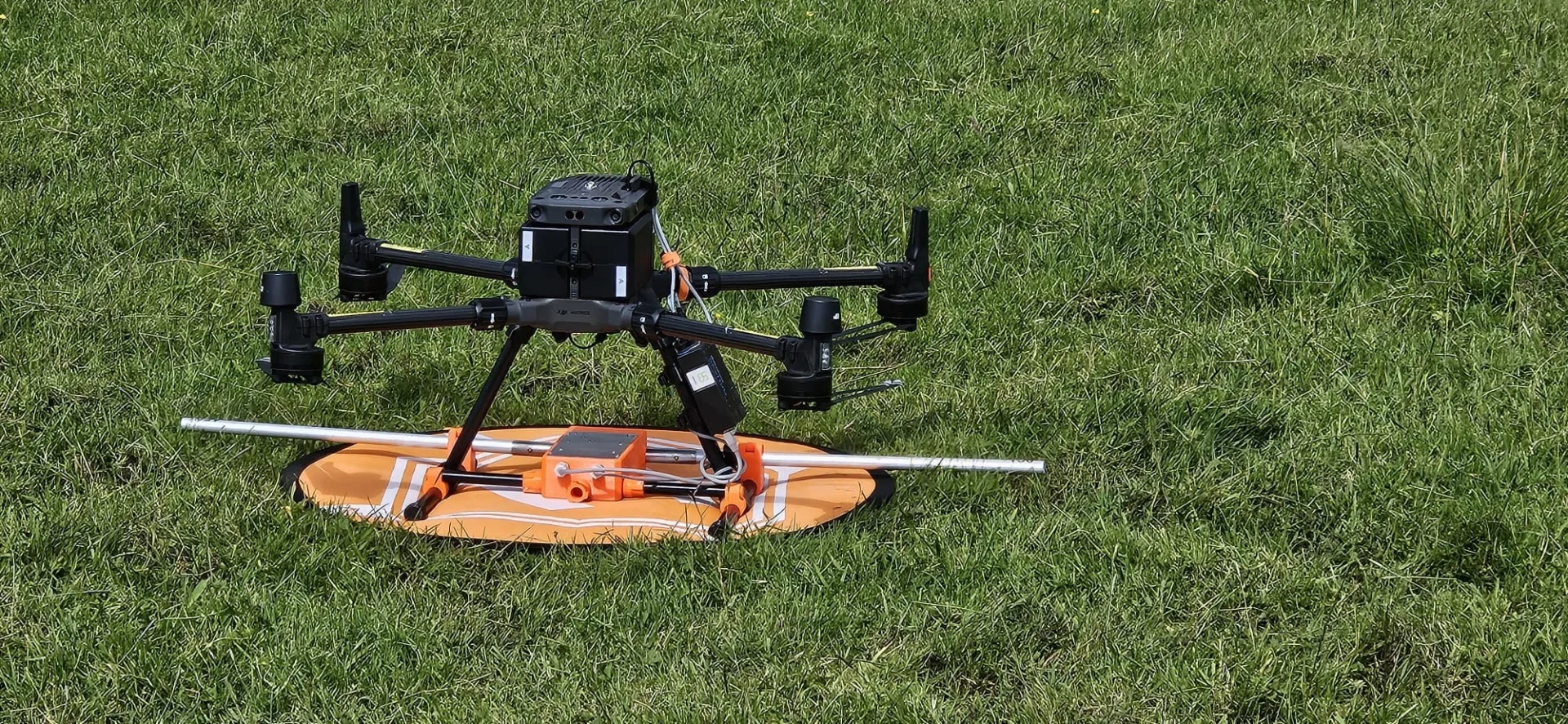
Drone Sonar Survey
While traditional underwater surveys rely on boat-mounted equipment, our drone sonar survey technology offers unprecedented flexibility and cost efficiency. Our specialized drones deploy advanced sonar devices that create detailed acoustic images of underwater environments without requiring large vessels or extensive crews.
We’ve designed our systems to operate in locations inaccessible to conventional survey boats, including shallow waters, remote lakes, and hazardous areas. The drones transmit real-time data to our technicians, allowing immediate analysis and quicker decision-making.
Each survey is customized to your specific requirements, whether you need comprehensive seabed mapping, structural inspections, environmental assessments, or search operations. We’ve refined our methodologies to ensure minimal environmental impact while delivering highly accurate results that meet or exceed industry standards.


What Is Drone Sonar Surveying
Drone sonar surveying combines aerial technology with underwater acoustics to create a revolutionary mapping system. Our specialized drones carry lightweight sonar devices that emit sound waves toward water bodies. These waves bounce off underwater features and return to the receiver, generating detailed data about depth, contours, and submerged objects.
Unlike traditional methods requiring boats and large crews, our drone-based approach allows access to remote or hazardous locations with minimal environmental impact. We can quickly deploy our equipment to capture comprehensive bathymetric data from lakes, rivers, coastal areas, and even flooded zones.
The real-time data we collect is processed through advanced software to create 3D models, topographical maps, and volumetric calculations. This technology delivers superior accuracy while significantly reducing survey time and operational costs.
How Our Drone Sonar Surveys Work
Our drone sonar survey process begins with a thorough site assessment and customized planning phase tailored to your specific underwater environment. We then deploy our advanced drone-mounted sonar systems to efficiently collect high-resolution underwater data without the risks associated with traditional diving methods. After acquisition, we transform the collected data using advanced processing techniques into detailed 3D visualizations and comprehensive reports that clearly identify all underwater features of interest.

Site assessment and survey planning
Before any drone takes flight, comprehensive site assessment and survey planning establish the foundation for successful sonar data collection. We begin by analyzing satellite imagery and existing topographic data to identify potential obstacles and optimal flight paths.
Our team conducts thorough site visits to verify conditions, noting features that might affect signal quality or drone navigation. We’ll assess environmental factors like wind patterns, water turbidity, and potential electromagnetic interference sources.
We then develop tailored flight plans specifying altitude, speed, and sonar frequency settings optimized for your specific requirements. Our proprietary planning software calculates precise grid patterns ensuring complete coverage with appropriate overlap between scan lines.
We’ll also secure necessary permits and inform relevant authorities about our operations. This meticulous planning phase typically takes 3-5 days but saves significant time during execution while maximizing data quality.
Deployment of drone-mounted sonar systems
With planning complete, our field operations begin. We transport our specialized drones to your site, where our technicians conduct pre-flight checks of all equipment. This includes calibrating the sonar systems and verifying integration with GPS for precise positioning.
Our operators launch the drones according to the predetermined flight plan, maintaining line-of-sight control while monitoring real-time data feeds. The drones hover at optimal heights above the water surface as the sonar systems collect depth measurements and subsurface imagery.
During deployment, we constantly monitor weather conditions and make adjustments as needed. Multiple flight patterns ensure comprehensive coverage of the survey area. Our team processes preliminary data on-site to verify quality before concluding the field operation, ensuring we’ve captured all required information before demobilization.


Underwater data acquisition and collection
Once our drones are hovering in position, the underwater data acquisition process begins through our advanced sonar technology. Our systems emit sound pulses that travel through water and bounce back when they encounter objects, creating detailed acoustic imagery of underwater environments.
We collect three primary data types: bathymetric measurements for precise depth mapping, side-scan imagery for seafloor visualization, and sub-bottom profiles that reveal sediment layers beneath the surface. Our AI-enhanced processors filter noise and enhance signal quality in real-time, ensuring exceptional data clarity even in challenging conditions.
The collected data streams wirelessly to our survey vessels or shore stations where our technicians monitor quality and coverage. We’ve optimized our acquisition parameters for various environments—from shallow harbors to deep offshore sites—giving you comprehensive underwater insights without traditional survey limitations.
Advanced processing and 3D visualization
After collecting raw sonar data, our advanced processing pipeline transforms it into actionable 3D visualizations through three key steps.
First, we clean and filter the raw data to remove noise and anomalies. Our proprietary algorithms enhance signal clarity while preserving critical details, ensuring accuracy in all conditions.
Next, we apply advanced spatial modeling techniques to convert point clouds into detailed 3D models. We’re able to identify subtle features and structures that might otherwise go unnoticed in conventional surveys.
Finally, we render these models into interactive visualizations you can manipulate and explore. You’ll receive both high-resolution imagery and interactive 3D models that allow for precise measurements, cross-sectional analysis, and comprehensive spatial understanding. These visualizations provide the decision-making clarity you need for your underwater projects.

Comprehensive reporting with identified features
Every comprehensive survey culminates in our detailed reporting system that transforms raw data into actionable intelligence. We’ve designed our reports to highlight critical underwater features with precise GPS coordinates, dimensional measurements, and condition assessments.
Each report includes annotated sonar imagery, 3D renderings, and comprehensive maps that clearly identify structures, geological formations, and potential hazards. We’ll classify detected objects using our proprietary identification system, making it easy to distinguish between natural features and man-made structures.
You’ll receive both technical data for engineering applications and simplified visual summaries suitable for presentations to stakeholders. Our reports also include comparative analysis when historical survey data is available, allowing you to track changes in underwater environments over time.
Benefits of Drone Sonar Surveys
Our drone sonar surveys provide access to shallow and hazardous water bodies that traditional boats can’t reach, while completing projects in a fraction of the time. We’ve designed our technology to seamlessly integrate above and below water data, creating comprehensive maps of underwater features with exceptional detail. This innovative approach offers a cost-effective alternative to traditional survey methods without sacrificing quality or accuracy.


Access to shallow and hazardous water bodies
Traditional sonar surveys often face significant limitations when navigating shallow or hazardous water bodies, which is where drone technology truly shines. Our drones can access water as shallow as 30 centimeters, reaching areas that boats simply cannot navigate.
We’ve designed our systems to safely operate around submerged obstacles, underwater debris, and confined spaces like narrow channels or under bridges. This capability eliminates the safety risks associated with sending human divers or manned vessels into dangerous environments such as contaminated waters, areas with strong currents, or sites with underwater hazards.
The compact nature of our drones also means minimal environmental disruption—we don’t disturb sediments or aquatic habitats like larger vessels do. This makes our service ideal for environmentally sensitive areas where conventional survey methods might cause unacceptable damage.
Rapid survey completion compared to boat methods
Time efficiency represents one of the most compelling advantages our drone sonar survey service offers over conventional boat methods. While traditional boat surveys often require days or even weeks to complete, our drones can survey the same area in just hours.
We’ve eliminated time-consuming processes like boat launching, transportation logistics, and crew scheduling. Our drones deploy instantly, flying systematic survey patterns at 30mph—far faster than boats can safely navigate shallow waters. This speed doesn’t compromise data quality; in fact, our controlled flight paths ensure more consistent coverage.
For time-sensitive projects like emergency inspections or pre-construction assessments, this rapid deployment capability proves invaluable. You’ll receive comprehensive survey data and analysis significantly faster, allowing your projects to progress without delay and potentially reducing overall costs associated with extended survey timeframes.

Integration of above and below water data
Unlike conventional survey methods that treat waterline as a hard boundary, our drone sonar system seamlessly integrates above-water and below-water data into unified 3D models. This integration delivers a comprehensive view of your entire project area, eliminating information gaps at the waterline.
We merge aerial photogrammetry with bathymetric data to create complete terrain models that capture everything from shoreline features to underwater structures. This unified approach proves invaluable for coastal management, infrastructure inspection, and environmental assessment projects.
You’ll receive consistent datasets with matching resolution and coordinate systems, making analysis simpler and more accurate. Our clients appreciate how these integrated models reveal relationships between visible and submerged elements that would otherwise remain undetected using traditional, fragmented survey approaches.
Comprehensive mapping of underwater features
Our drone sonar technology reveals underwater features with unprecedented clarity and detail, mapping everything from submerged vegetation to complex geological formations. We’re able to identify hidden structures, shipwrecks, and natural habitats that traditional survey methods might miss.
The high-resolution data we collect creates complete 3D models of underwater environments, allowing you to visualize and analyze terrain with centimeter-level accuracy. This comprehensive mapping supports informed decision-making for environmental assessments, construction planning, and resource management.
Our drones efficiently cover large areas, reaching locations that would be dangerous or impractical for divers. We’ll provide you with actionable intelligence about underwater topography, depths, and obstructions, giving you a complete picture of what lies beneath the surface before you commit resources to your project.


Cost-effective alternative to traditional methods
Drone sonar surveys dramatically reduce costs compared to traditional underwater inspection methods. By eliminating the need for dive teams, boats, and extensive safety protocols, we’re able to offer our services at a fraction of conventional prices.
Our drones collect the same high-quality data without the logistical complexities of human-operated surveys. You’ll save on labor costs, equipment rental, and insurance premiums while minimizing operational downtime.
We complete most surveys in hours rather than days, further reducing your expenses. For recurring inspections, these savings compound significantly over time. Our clients typically report cost reductions of 40-70% compared to their previous survey methods.
The efficiency of our drone technology translates directly to your bottom line without compromising data quality or comprehensive coverage.
Drone Sonar Survey Services We Offer
Our comprehensive drone sonar survey services include underwater topography mapping and detailed inspection of submerged structures. We offer precise sediment analysis with volumetric calculations and expert marine habitat assessments to monitor ecosystem health. For risk management purposes, our advanced flood modeling capabilities help clients prepare for potential water-related hazards.

Underwater Topography Mapping
Precision mapping of underwater terrain provides crucial data for a variety of marine projects. Our drone-based sonar systems generate detailed 3D models of lake beds, river channels, and coastal areas with accuracy down to 10 centimeters.
We’ve perfected techniques for capturing complex underwater features including rock formations, shipwrecks, and submerged infrastructure. The data we collect helps identify erosion patterns, monitor sediment movement, and detect potential hazards to navigation.
Unlike traditional survey methods, our drones can access shallow or hazardous areas without risk to personnel. We deliver finished maps in multiple formats compatible with GIS systems, CAD software, and custom visualization tools. The comprehensive data sets we provide empower engineers, environmental scientists, and construction teams to make informed decisions based on accurate subsurface conditions.
Submerged Structure Inspection
When underwater infrastructure requires assessment, our sonar-equipped drones provide a cost-effective alternative to traditional dive teams. Our technology delivers detailed imagery of submerged bridges, dams, pipelines, and offshore installations without endangering human divers.
We specialize in identifying structural weaknesses, corrosion, and potential failure points that could lead to catastrophic outcomes if left undetected. Our high-resolution imaging captures millimeter-precise measurements of cracks, erosion, and material degradation.
The drones navigate tight spaces and hazardous environments where human access is limited, completing inspections in a fraction of the time traditional methods require. This efficiency translates to minimal operational downtime for your facilities while providing comprehensive documentation that meets regulatory compliance standards.


Sediment Analysis and Volumetrics
Through advanced bathymetric mapping technology, we deliver precise measurements of underwater sediment deposits and volumetric calculations that help you make informed decisions about dredging operations. Our sonar-equipped drones can detect sediment layers with centimeter-level accuracy, revealing critical accumulation patterns in reservoirs, harbors, and waterways.
We’ll analyze sediment composition and distribution, providing detailed reports on siltation rates and volumetric changes over time. This data allows you to optimize dredging schedules, estimate removal costs, and monitor environmental impacts.
Our volumetric calculations include:
- Total sediment volume measurement
- Deposition rate analysis
- Capacity loss assessment
- Material classification
- Dredge planning support
When you need reliable underwater sediment data for project planning or regulatory compliance, our drone sonar mapping delivers actionable insights quickly and affordably.
Marine Habitat Assessment
Our cutting-edge drone sonar technology enables comprehensive marine habitat assessment with minimal environmental disruption. We map and classify benthic habitats through high-resolution acoustic imaging that identifies seagrass beds, coral reefs, and other critical marine ecosystems.
We’ve developed specialized algorithms that analyze acoustic data to distinguish between different substrate types and vegetation densities. This allows us to monitor habitat health over time, tracking changes that might indicate environmental stressors or recovery.
Our reports include detailed habitat distribution maps, species identification where possible, and quantitative measurements of coverage areas. Conservation groups, government agencies, and marine protected area managers rely on our data for evidence-based decision making. We’re proud that our non-invasive approach helps protect the very ecosystems we’re studying.

Flood Risk Modeling
As climate change intensifies extreme weather events, comprehensive flood risk modeling has become essential for community planning and disaster preparedness. Our drone sonar surveys provide crucial data for developing accurate flood prediction models.
We capture detailed topographical information of riverbanks, floodplains, and urban drainage systems through high-resolution sonar scanning. This data helps identify potential flow paths, bottlenecks, and vulnerable infrastructure. Our 3D terrain models integrate with hydrological software to simulate various flooding scenarios.
We’ve helped municipalities create flood hazard maps that inform zoning decisions and emergency response protocols. By combining historical flood data with current terrain conditions, we deliver actionable intelligence that protects communities and critical infrastructure. Our modeling has proven valuable for insurance assessments, urban development planning, and climate adaptation strategies.
Underwater Obstacle Detection
Detecting hidden underwater hazards requires specialized technology that conventional visual inspections cannot provide. Our drone-mounted sonar systems penetrate murky waters to reveal submerged objects with remarkable precision, creating detailed 3D maps of underwater environments.
We’re able to identify everything from sunken debris and abandoned equipment to natural formations that could pose navigation risks. This capability is crucial for marine construction projects, harbor management, and recreational waterway safety.
Our drones efficiently scan large areas in a fraction of the time required by traditional diving teams, reducing costs while enhancing safety. The real-time data we collect helps clients make informed decisions about obstacle removal, navigation planning, or infrastructure placement without the delays associated with conventional underwater surveys.


Archaeological Feature Mapping
Beneath the waves lie countless historical treasures waiting to be documented, which is why we’ve developed specialized drone sonar mapping for archaeological sites. Our drones create precise 3D models of submerged ruins, shipwrecks, and artifacts without disturbing these fragile remnants.
We’ve successfully mapped ancient harbors, sunken cities, and colonial-era vessels with centimeter-level precision. Our technology differentiates between natural formations and man-made structures, revealing hidden features that traditional surveys might miss.
Archaeologists appreciate our ability to survey large areas quickly, providing comprehensive data that helps prioritize diving resources. We deliver actionable insights through detailed maps, depth measurements, and anomaly identification. This information proves invaluable for preservation planning, academic research, and site monitoring to protect our underwater cultural heritage.
Water Depth Profiling
Our water depth profiling service employs cutting-edge sonar technology to deliver highly accurate bathymetric data for a variety of marine environments. We capture detailed measurements of underwater terrain, creating comprehensive depth maps critical for safe navigation, construction projects, and resource management.
Our drone-mounted sonar systems can efficiently survey large areas, including harbors, lakes, rivers, and coastal zones. We’re able to reach shallow or hazardous locations that traditional survey vessels can’t access, providing invaluable data without putting personnel at risk.
Each survey delivers precisely georeferenced depth information with centimeter-level accuracy. We process this data into intuitive 3D models and contour maps that clearly visualize underwater topography, helping you make informed decisions for your marine-based projects.

Technology We Use for Sonar Surveys
Modern sonar technology forms the backbone of our underwater survey capabilities. We employ advanced multibeam echosounders mounted on our specialized drones, capable of generating high-resolution 3D maps of underwater terrain. These systems emit sound waves at frequencies between 200-700 kHz, providing accuracy within 2cm.
Our drones feature integrated RTK GPS positioning that ensures precise georeferencing of all collected data. We’ve also implemented advanced motion compensation systems that correct for wave action, maintaining data quality even in challenging conditions.
For deeper surveys, we utilize side-scan sonar arrays that provide detailed imaging of underwater structures up to 100m beneath the surface. All data is processed through our proprietary software that filters noise and enhances signal clarity, delivering survey results that exceed industry standards.
Applications Across Industries
Our drone sonar survey services support numerous industries with precision underwater mapping. We’ve successfully assisted clients with water resource management, port maintenance, coastal mapping, environmental monitoring, and construction projects. Whether you’re planning dredging operations or need detailed bathymetric data for infrastructure development, our technology delivers accurate subsurface insights.


Water resource management
Amid growing concerns over water scarcity and resource management, drone sonar surveys have emerged as vital tools for efficient water resource management. We’re helping municipalities and water authorities gain unprecedented insights into their aquatic resources through our comprehensive drone sonar solutions.
Our drones map reservoir capacities with precision, identifying sedimentation buildup that reduces storage capacity. We detect underwater obstacles, leaks in dams, and monitor infrastructure integrity without costly draining operations. The data we collect helps optimize irrigation systems and supports groundwater monitoring efforts.
Port and harbor maintenance
Maritime infrastructure requires constant monitoring and maintenance to ensure safe, efficient operations. Our drone sonar systems excel in port and harbor environments where regular inspections are critical.
We map underwater structures, detect potential hazards, and identify areas needing immediate attention. Our technology easily locates submerged debris, monitors siltation levels, and assesses the condition of quay walls, piers, and breakwaters without disrupting daily port activities.
Port authorities value our precise depth measurements that highlight areas requiring dredging, keeping navigation channels at optimal depths. We’ve helped numerous harbors improve their maintenance schedules by providing comprehensive underwater data that traditional survey methods miss. Our rapid deployment capability also means we can conduct emergency assessments following storms or shipping incidents.

Coastal zone mapping
Coastal environments represent some of the most dynamic and vulnerable areas on our planet, requiring detailed mapping for effective management and protection. Our drone sonar systems excel in these challenging interfaces between land and sea, capturing high-resolution data of shorelines, nearshore bathymetry, and coastal features.
We’ve mapped eroding coastlines for municipalities developing protection strategies, surveyed wetlands for conservation efforts, and monitored beach morphology changes after storm events. Our drones efficiently cover expansive coastal areas while accessing shallow zones inaccessible to traditional survey vessels. The data we provide helps coastal managers, environmental scientists, and urban planners make informed decisions about development, conservation, and climate change adaptation. Unlike conventional mapping methods, our drone-based approach delivers comprehensive coastal mapping at reduced costs and environmental impact.
Environmental monitoring
Environmental monitoring represents a cornerstone application of our drone sonar technology across multiple industries. We’re helping clients track habitat changes, detect pollution sources, and monitor protected marine environments with unprecedented efficiency.
Our sonar-equipped drones map coral reef degradation, measure sediment volumes, and identify areas affected by industrial discharge. We’ve developed specialized algorithms that detect subtle changes in aquatic ecosystems over time, providing crucial data for conservation efforts.
Climate researchers value our ability to track ice melt patterns and coastal erosion rates. Water management agencies use our services to monitor reservoir conditions and stormwater system integrity. For environmental compliance, we offer regular monitoring programs that provide consistent, reliable data with minimal disturbance to sensitive ecosystems.


Construction and dredging
When undertaking major infrastructure projects near or underwater, our drone sonar survey service provides critical data that streamlines construction and dredging operations while reducing costs. We’ll map the underwater terrain with centimeter-level accuracy, identifying potential hazards before your equipment arrives on site.
Our drones can monitor dredging progress in real-time, ensuring you maintain proper depths while avoiding over-excavation. This capability is especially valuable for harbor expansions, pipeline installations, and bridge construction.
We’re also equipped to perform pre- and post-project surveys to document site conditions, which helps verify contract compliance and resolve potential disputes. By deploying our automated system rather than traditional survey boats, you’ll complete underwater surveys faster, with fewer personnel, and maintain higher safety standards throughout your project.
Search and recovery operations
In critical search and recovery operations, our drone sonar technology proves invaluable across three key sectors: law enforcement, disaster response, and marine salvage.
For law enforcement agencies, we provide rapid underwater evidence location and recovery, helping solve cases by finding submerged weapons, vehicles, or other crucial items without endangering dive teams during initial searches.
When disasters strike, our drones quickly assess submerged structures and locate victims in flood zones or waterways, dramatically reducing response time and improving survival chances.
Marine salvage operations benefit from our detailed underwater mapping of shipwrecks and lost cargo. We’ll identify exact positions of valuable materials and assess structural integrity before sending recovery teams, saving both time and resources while enhancing safety.

Why Choose Our Drone Sonar Survey Team
Our experienced team stands apart in the drone sonar survey industry with over 15 years of combined expertise and cutting-edge technology. We’ve successfully completed more than 200 underwater surveys across diverse environments from murky lakes to turbulent coastal waters.
Our drones carry the latest multi-beam sonar systems with 4K imaging capabilities, delivering accuracy within 10cm—twice the industry standard.
Choose us for a partner who prioritizes safety, efficiency, and precision while saving you significant time and resources on your underwater projects.


Contact Us For Your Drone Sonar Survey Needs
Ready to gain unprecedented underwater insights with our advanced drone sonar survey technology? Our specialized UAV-mounted sonar systems provide detailed underwater mapping, submerged object detection, and comprehensive bathymetric data without the need for boats or divers.
Reach out today through our dedicated hydrographic line at +44 7368 537499 or email us at Jamie@skykam.co.uk. We’ll respond within 24 hours to arrange your free consultation.
When contacting us, please share details about your water body location, depth requirements, and specific survey objectives. This information helps us configure our equipment for optimal results in your unique underwater environment. We serve clients throughout the UK for projects involving reservoirs, lakes, rivers, coastal areas, and marine infrastructure.
Let’s collaborate to unlock valuable subsurface data with our innovative drone sonar survey solutions that combine aerial efficiency with underwater precision.