You’re considering a becoming a drone surveyor in the UK, and it’s a smart move. This field combines cutting-edge technology with practical surveying applications, offering excellent earning potential and diverse work environments.
The demand for qualified drone operators continues to grow as more industries recognize the efficiency and cost-saving benefits of aerial surveying. But how do you break into this specialized field?
The path involves specific certifications, equipment investments, and skill development that might not be immediately obvious.

30 Second Summary
- Complete a CAA-approved training program and obtain either an A2 CofC or GVC certification.
- Apply for Operational Authorisation from the Civil Aviation Authority after completing your GVC.
- Invest in professional-grade drones with RTK capabilities and master photogrammetry software.
- Develop skills in flight planning, data processing, and creating deliverables from drone imagery.
- Build a portfolio through practice projects and consider whether to pursue freelancing or full-time employment.

Obtain Required Certifications and Licenses
The first step to becoming a drone surveyor in the UK is acquiring proper certification through a CAA-approved training program.
You’ll need to choose between two main qualifications: the A2 Certificate of Competency (A2 CofC) for smaller drone operations or the General Visual Line of Sight Certificate (GVC) for more advanced work.
| Feature | A2 Certificate of Competency (A2 CofC) | General Visual Line of Sight Certificate (GVC) |
|---|---|---|
| Suitable for | Smaller drone operations | Advanced surveying work |
| Flight restrictions | Limited operations | More flexibility in operational areas |
| Application process | Simpler, faster | More comprehensive |
| Cost | £300-£500 | £500-£800 |
| Renewal period | Every 5 years | Every 5 years |
| Ideal for | Beginners, small projects | Professional surveyors, complex projects |
The certification process covers essential knowledge including drone laws, flight planning, and safety procedures to ensure regulatory compliance. These qualifications aren’t just bureaucratic requirements—they’re designed to make you a competent, safe drone operator.
After completing your GVC, you’ll need to apply to the Civil Aviation Authority for an Operational Authorisation. This application typically takes a few weeks to process, so plan accordingly when establishing your timeline.

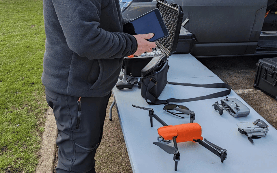
Invest in the Right Drone Surveyor Equipment and Technology
After completing your certifications, you’ll need to invest in professional-grade equipment that meets surveying standards. When considering drone selection, prioritize models like the DJI Matrice 300 RTK, which offers superior flight stability and extended flight times crucial for comprehensive surveys.
| Drone Model | Price Range | Flight Time | RTK Capable | Payload Capacity | Best For |
|---|---|---|---|---|---|
| DJI Matrice 300 RTK | £5,000-£7,000 | 55 minutes | Yes | Multiple sensors | Professional surveying |
| DJI Phantom 4 RTK | £5,500-£6,500 | 30 minutes | Yes | Single camera | Mapping, small surveys |
| Wingtra One | £18,000-£20,000 | 59 minutes | Yes | Various payloads | Large-scale mapping |
| Autel EVO II RTK | £3,500-£4,500 | 40 minutes | Yes | 8K camera | High-resolution imagery |
Ensure your drone has RTK capabilities for centimeter-level positioning accuracy—an absolute necessity for professional surveying work. You’ll also need to master photogrammetry software to transform your aerial imagery into valuable deliverables like orthomosaics and 3D models.
Don’t overlook equipment maintenance as part of your investment strategy. Regular calibration and servicing will extend your drone’s lifespan and maintain survey accuracy. Budget for specialized payloads that enhance data collection capabilities, as these tools directly impact the quality of your survey deliverables.

Develop Essential Drone Surveyor Skills and Knowledge
Successful drone surveyors balance technical expertise with practical field knowledge that extends far beyond basic piloting abilities. You’ll need to master photogrammetry basics, including camera calibration, image overlap, and setting ground control points for accurate data collection.
Develop proficiency in creating 3D point clouds from overlapping 2D images and learn the data processing techniques needed to transform raw footage into valuable deliverables. Mission planning is equally crucial—assess sites for obstacles, define clear objectives, and design optimal flight paths.
Your ability to analyze data and produce comprehensive reports will ultimately determine your value to clients. Focus on developing these specialized skills alongside your flying abilities to establish yourself as a competent drone surveyor in the UK market.

Gain Practical Experience and Build a Portfolio
Moving beyond theoretical knowledge, practical experience forms the backbone of your drone surveying career. Begin by creating mock projects in open spaces where you can safely practice flight operations and develop your data collection workflow.
Challenge yourself by flying in varying conditions to build confidence in your piloting abilities.
Seek internship opportunities with surveying companies, engineering firms, or environmental agencies. Working alongside experienced professionals provides invaluable insights into real-world project demands and industry standards. These mentored experiences will accelerate your learning curve tremendously.
Throughout this practical learning phase, document your work meticulously. Capture before-and-after imagery, create sample maps, and record your workflow improvements.
This documentation becomes your professional portfolio—concrete evidence of your capabilities that will speak volumes to potential clients or employers.

Choose Your Drone Surveyor Career Path and Maximize Earnings
When planning your drone surveying career, you’ll need to make a fundamental choice between freelancing and full-time employment.
Full Time Employment
Full-time positions with employers like Balfour Beatty, Ordnance Survey, and the Environment Agency offer stability, structured advancement, and employer benefits including consistent income and professional development.
Freelancing
Freelancing provides flexibility and higher earning potential through strategic pricing models. Maximize revenue with these freelancing strategies: bundle complementary services, specialize in high-demand niches, and maintain a diverse client base across multiple sectors.
With experience, you can progress to roles like Chief Drone Pilot, UAV Operations Manager, Consultant, or Instructor.
| Position | Experience Level | Annual Salary Range | Additional Benefits |
|---|---|---|---|
| Entry-level Drone Operator | 0-2 years | £25,000-£35,000 | Training opportunities |
| Mid-level Drone Surveyor | 2-5 years | £35,000-£50,000 | Project bonuses |
| Senior Drone Surveyor | 5+ years | £50,000-£70,000 | Profit sharing, equipment allowance |
| UAV Operations Manager | 7+ years | £60,000-£80,000 | Management bonuses, company vehicle |
| Drone Surveying Consultant | 10+ years | £70,000-£100,000 | Flexible schedule, equity options |
Consider investing in specialized skills like thermal imaging or LiDAR to command premium rates.

Conclusion
You’re now ready to launch your drone surveying career in the UK. With proper certifications, quality equipment, and developed skills in your toolkit, you’ll stand out in this growing field.
Remember, practical experience is crucial, so keep building your portfolio. Whether you choose freelancing or full-time employment, you’re positioned to earn between £40,000-£70,000 annually in this exciting profession.
In this guide, we’ll walk you through the training process, certification options, and what to expect as you prepare for a career in drone surveying.
