Need accurate underwater mapping? Save time, cut costs, and get crystal-clear insights with our advanced drone bathymetric survey services.
Don’t settle for risky, time-consuming traditional methods when our enterprise-grade drone sonar technology delivers faster, safer underwater topography results.
As specialists in drone bathymetric mapping and underwater terrain assessment since 2016, we provide the actionable depth measurement data you need for critical water-based project decision-making.
Used By Top UK Businesses

👇Fill Out The Form For Same-Day Drone Survey Quote 👇
Why Leading UK Businesses Choose Our Drone Survey Services:
✅ We’re Fully Licensed, Insured Drone Pilots
✅ We Cover the UK with Fast Response Times
✅ We Only Use Top-Quality Drone Equipment
✅ We Customize Solutions for Your Industry
✅ We Handle All the Paperwork and Permissions
✅ We Have Worked with Hundreds of Happy Customers

What Is Drone Bathymetric Survey?
A drone bathymetric survey is a method of mapping the underwater topography of bodies of water using drones equipped with specialized sensors. These drones typically carry echo sounders or LiDAR systems that can measure the depth and contours beneath the water’s surface. The collected data creates detailed maps or models of the seafloor, riverbeds, lakes, or reservoirs. Unlike traditional boat-based surveys, drone bathymetric surveys are faster, safer, and can access hard-to-reach areas.
This technique is widely used for environmental monitoring, construction projects, dredging, and flood risk assessment. It provides accurate, high-resolution data essential for planning and decision-making in marine and freshwater environments.


How Our Drone Bathymetric Surveys Work
Our drone bathymetric survey process begins with comprehensive site assessment and planning before deploying aerial drones equipped with sonar technology for data collection. We process the captured depth and imagery data to create detailed underwater topographic maps that reveal subsurface conditions with remarkable precision. These maps, along with our thorough analysis and reporting, provide clients with actionable insights about underwater environments for informed decision-making.
Site assessment and survey planning
Before initiating any drone bathymetric survey, we conduct a thorough site assessment to identify potential obstacles, environmental factors, and regulatory requirements that might affect operations. This includes analyzing satellite imagery, reviewing existing bathymetric data, and evaluating local water conditions like turbidity, currents, and tidal variations.
Our planning process incorporates flight path optimization using specialized software that accounts for water depth ranges, drone battery limitations, and required data resolution. We’ll create a detailed survey grid with appropriate overlap between flight lines to ensure complete coverage and data quality.
We’ll also secure all necessary permits, coordinate with local authorities, and establish safety protocols specific to your site. Weather forecasting is critical—we’ll schedule optimal survey windows to maximize data accuracy while minimizing environmental interference.

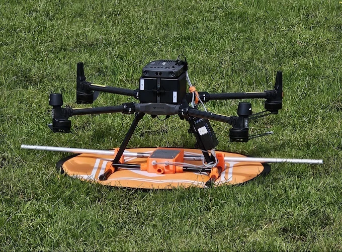
Combined aerial drone and sonar data collection
When conducting bathymetric surveys, we’ve developed a sophisticated data collection system that seamlessly integrates aerial drone technology with advanced sonar equipment. Our drones capture high-resolution aerial imagery of the water surface and shoreline while simultaneously deploying floating sonar units that measure water depth and bottom contours.
This dual-approach methodology allows us to create comprehensive 3D models of both above-water and underwater environments in a single operation. We’ve optimized our workflow to ensure the georeferenced aerial data aligns perfectly with the sonar readings, eliminating the spatial inconsistencies common in traditional separate surveys. The synchronized data streams are processed through our proprietary software that automatically correlates surface features with underwater topography, producing accurate bathymetric maps that reveal the complete aquatic landscape.
Processing of depth and imagery data
Processing of depth and imagery data requires sophisticated software solutions to transform raw measurements into actionable insights. Once collected, we import sonar data into specialized bathymetric processing software where we apply corrections for water surface fluctuations, sound velocity variations, and vessel motion.
We then merge this depth data with our drone imagery through photogrammetric techniques. By georeferencing both datasets, we create precise 3D models of underwater terrain aligned perfectly with above-water features. Our processing pipeline includes noise filtering algorithms to remove erroneous data points and interpolation methods to fill data gaps.
The final outputs typically include high-resolution bathymetric maps, contour lines, cross-sections, and volumetric calculations. We’ll deliver these in industry-standard formats compatible with GIS software, ensuring you can easily integrate our results into your existing workflows.


Creation of detailed underwater topographic maps
The creation of detailed underwater topographic maps represents the culmination of our survey and processing efforts. After collecting and processing depth data, we transform these measurements into comprehensive 3D models of underwater terrain. We employ specialized GIS software that converts our point cloud data into contour lines, depth gradients, and digital surface models.
We’ll deliver these maps in multiple formats suited to your needs, including high-resolution PDFs, interactive digital models, and GIS-compatible shapefiles. Each map features color-coded depth zones, clear annotations of underwater features, and scale references. For enhanced visualization, we can overlay aerial imagery on bathymetric data, creating a complete picture of both above and below water surfaces. These maps provide invaluable insights for coastal management, construction planning, environmental monitoring, and navigation safety.
Analysis and reporting of findings
After completing the bathymetric survey and data processing, we conduct comprehensive analysis to extract meaningful insights from your underwater terrain data. We identify key features such as channels, shoals, sediment deposits, and erosion patterns that affect waterway management decisions.
Our reporting includes detailed bathymetric maps with multiple visualization options, cross-sectional profiles, and volumetric calculations. We’ll highlight areas of concern and provide depth comparisons with historical data when available. For environmental projects, we analyze habitat suitability and potential impact zones.
You’ll receive our findings in a customized format that meets your specific requirements—whether that’s engineering specifications for dredging operations, environmental impact assessments, or infrastructure planning support. We’re always available to explain our analysis and help you interpret the results for your decision-making process.

Benefits of Drone Bathymetric Surveys
Our drone bathymetric surveys excel where traditional boat methods can’t reach, providing access to shallow water areas previously unmapped. We’ve cut survey completion times significantly while keeping our teams safer by avoiding dangerous water conditions entirely. The comprehensive data we deliver combines both above-water and underwater visualizations, giving you the complete picture of your waterway environment.
Access to shallow waters unreachable by boats
Unlike traditional survey vessels, drones can efficiently access shallow water bodies where boats simply cannot navigate. We’re able to collect detailed bathymetric data from streams as shallow as 10cm, tidal pools, and narrow channels without disturbing sensitive ecosystems.
Our drone technology excels in mapping complex shorelines with submerged rocks, sandbars, and vegetation that would damage conventional boats. We’ve successfully mapped remote wetlands, mountain streams, and coastal reefs that previously remained uncharted due to access limitations.
This capability proves invaluable for environmental monitoring, where we can track erosion patterns and habitat changes in delicate ecosystems. For construction and engineering clients, we provide comprehensive underwater topography of hard-to-reach areas, eliminating the need for expensive manual surveys or the risks associated with deploying human divers in challenging conditions.


Significant time reduction compared to traditional methods
Compared to conventional vessel surveys that typically require weeks of planning and execution, drone bathymetric surveys can complete the same project in just days—often reducing overall survey time by up to 80%. Our teams deploy rapidly with minimal equipment and fewer personnel, eliminating the logistical complexities of boat-based operations.
We’ve eliminated the time-consuming process of launching vessels, navigating to survey sites, and managing crew rotations. Data collection happens simultaneously across multiple zones rather than sequentially. The post-processing workflow is also streamlined, as our specialized software integrates seamlessly with the drone-collected data.
For time-sensitive projects like emergency assessments after storms or monitoring rapidly changing coastal environments, this efficiency isn’t just convenient—it’s critical. We’ll deliver actionable insights while traditional methods are still in their preparation phase.
Enhanced safety in dangerous water conditions
Safety considerations become paramount when conducting surveys in high-risk aquatic environments, which is why our drone bathymetric approach significantly reduces personnel exposure to dangerous conditions. Our operators remain safely on shore while drones navigate treacherous waters, swift currents, and contaminated areas that would otherwise pose serious risks to human surveyors.
We’ve eliminated the need for personnel to enter dangerous waters in scenarios involving unstable shorelines, submerged hazards, and extreme temperature conditions. This approach is particularly valuable during flood monitoring, disaster response, and surveys near industrial outfalls. When conventional boat-based surveys would place our team in harm’s way, our drones deliver accurate bathymetric data without compromising anyone’s wellbeing. The technology not only protects our staff but also enables us to collect data in previously inaccessible or prohibitively dangerous locations.

Comprehensive above and below water visualization
Our advanced drone bathymetric systems offer a unique advantage beyond safety benefits—they capture complete visualization of environments both above and below the waterline simultaneously. This dual perspective creates a comprehensive dataset that traditional methods simply can’t match.
We’ve integrated high-resolution cameras and LiDAR with subsurface sonar technology, allowing us to develop detailed 3D models that seamlessly blend terrestrial and underwater features. You’ll see everything from shoreline erosion patterns to submerged structures in one cohesive view.
These unified visualizations dramatically improve project planning and environmental assessments. Instead of piecing together separate surveys, stakeholders can immediately understand the complete context of waterways, facilitating better decision-making. For coastal management, infrastructure development, or environmental monitoring, this holistic approach provides insights that were previously impossible to achieve without extensive, multi-phase survey operations.
Drone Bathymetric Survey Services We Offer
Our comprehensive drone bathymetric survey services span multiple aquatic environments to meet your specific needs. We provide detailed mapping for reservoirs and lakes, precise coastal zone mapping, thorough river and stream surveys, and essential support for construction and dredging projects. Each service utilizes cutting-edge drone technology to deliver accurate underwater topographical data while saving you time and resources compared to traditional survey methods.


Reservoir and Lake Mapping
When managing reservoirs and lakes effectively, accurate underwater mapping becomes essential for both operational and environmental purposes. Our drone bathymetric surveys provide comprehensive data for water volume calculations, giving you precise measurements to inform water resource management decisions.
We’re experts at assessing sediment accumulation in reservoirs, helping you understand deposition patterns that affect storage capacity over time. Our high-resolution mapping documents underwater structures like intake towers and spillways, providing valuable information for infrastructure planning.
We also specialize in habitat mapping, identifying submerged vegetation, fish habitats, and other ecological features crucial for environmental studies. This detailed mapping supports dam inspection protocols and maintenance planning, allowing you to identify potential issues before they become costly problems. With our services, you’ll gain invaluable insights for responsible reservoir and lake management.
Coastal Zone Mapping
Moving from inland waters to the dynamic coastal environment requires specialized mapping solutions. Our drone bathymetric surveys excel in coastal zones, where we monitor shoreline erosion with precision and track sand movement patterns over time to assess environmental changes.
We identify underwater obstacles that pose risks to swimmers and vessels, helping maintain safety in recreational areas. Our team regularly conducts navigation channel assessments to ensure safe passage for maritime traffic and documents seabed structures with high-resolution imaging.
These capabilities prove invaluable for coastal management projects, environmental impact studies, and development planning. By capturing detailed data on beach profiles and nearshore bathymetry, we provide decision-makers with accurate information about coastal conditions and changes that traditional methods simply cannot match.

River and Stream Surveys
Three key advantages make drone bathymetric surveys ideal for river and stream environments. First, they’re perfect for assessing flood risks by creating detailed models of riverbed topography and flow patterns that help predict potential flooding events.
We regularly deploy drones to monitor erosion and deposition processes in dynamic river systems, tracking changes over time to inform effective management strategies. Our surveys also provide critical data for waterway navigation planning, identifying hazards and determining optimal routes for both recreational and commercial vessels.
Additionally, we’re committed to supporting ecological research through comprehensive habitat assessments for aquatic species. By mapping underwater features like pools, riffles, and submerged vegetation, we document hydrological characteristics that would otherwise remain invisible from traditional survey methods, creating valuable baselines for environmental monitoring programs.
Construction and Dredging Support
Our construction and dredging support services leverage advanced drone bathymetric technology to optimize underwater operations through every project phase. We conduct comprehensive pre-dredging surveys with precise volume calculations to establish baselines and determine exact material quantities requiring removal.
During operations, we provide real-time progress monitoring, allowing contractors to track efficiency and make immediate adjustments as needed. Once work is completed, our post-dredging verification surveys document final conditions and confirm compliance with project specifications.
For underwater construction sites, we deliver detailed assessments that identify potential hazards and optimal positioning for structures. Throughout material extraction projects, our monitoring services generate accurate reports tracking volumes removed and environmental impacts. We’re committed to delivering the data you need to keep dredging and construction projects on schedule and within budget.


Real-Time Data Collection and Processing Advantages
While traditional bathymetric surveys often require weeks of post-processing before data becomes usable, drone-based systems now offer significant real-time capabilities that transform fieldwork efficiency. Our drones transmit data directly to field computers where preliminary analysis occurs instantly, allowing our technicians to verify data quality and coverage while still on site.
We’ve integrated advanced processing algorithms that generate preliminary depth maps and 3D visualizations within hours rather than weeks. This means we can identify issues, adjust survey parameters, or collect additional data during the same deployment—saving you time and money.
These real-time capabilities are particularly valuable for time-sensitive projects like emergency response or when decisions need to be made quickly based on current underwater conditions.
We serve Wide Range Of Industries
Our drone bathymetric survey solutions support diverse industry needs, from environmental conservation and water resource management to marine construction and engineering. We’re equipped to assist in flood risk assessment and mitigation efforts, providing critical data for disaster planning and response. Port and harbor maintenance teams rely on our accurate underwater mapping to ensure navigational safety and efficient operations.

Environmental conservation
Environmental stewardship drives our passion for marine conservation through state-of-the-art drone bathymetric surveys. We’re committed to preserving aquatic ecosystems by providing high-resolution bottom mapping that monitors habitat changes with minimal environmental impact.
Our drones help conservation teams track coral reef health, document seagrass restoration, and identify sensitive marine zones requiring protection. We’ve supported initiatives to map coastal erosion patterns, monitor illegal fishing activities, and assess pollution impacts on underwater environments.
Water resource management
Water resource management encompasses a broad spectrum of industries that benefit from our advanced drone bathymetric survey capabilities. We help municipalities monitor reservoir levels and detect sedimentation that impacts water storage capacity. Our precise depth measurements enable dam operators to maintain optimal water levels and plan maintenance effectively.
For irrigation districts, we map canals and water distribution networks to identify obstructions and capacity issues. Our surveys assist in designing efficient flood control systems by providing accurate topographic and underwater data for modeling water flow dynamics.
We’ve worked with water utilities to inspect underwater infrastructure without costly draining procedures. Our drones detect leaks, erosion, and structural issues in water supply systems, helping managers prioritize repairs and prevent service disruptions. The data we provide improves decision-making for sustainable water resource allocation.


Marine construction and engineering
Marine construction and engineering projects benefit tremendously from our precise bathymetric surveys, which provide critical underwater intelligence for informed decision-making. We’ve helped numerous clients assess underwater conditions before, during, and after construction phases of bridges, piers, offshore platforms, and underwater pipelines.
Our drone bathymetric surveys deliver high-resolution data that accurately maps seafloor topography, identifies potential hazards, and monitors structural integrity of existing marine infrastructure. This information proves invaluable for planning dredging operations, positioning anchors, and ensuring proper foundation placement.
We’re uniquely equipped to survey difficult-to-access areas where traditional survey vessels can’t operate safely. Our technology reduces costs while improving data quality compared to conventional methods, allowing engineers to optimize designs, minimize environmental impacts, and enhance project safety through comprehensive subsurface visualization.
Flood risk assessment and mitigation
When communities face increasing flood threats due to climate change and urban development, our drone bathymetric surveys provide critical data for comprehensive flood risk assessment and mitigation strategies. We map riverbed topography, floodplain contours, and channel geometries with unprecedented accuracy.
Our teams work with municipal authorities and emergency management agencies to identify flood-prone areas, measure water retention capacities, and evaluate existing flood defenses. The high-resolution data we collect feeds directly into hydraulic models that simulate flooding scenarios and predict inundation zones.
We’re helping communities develop targeted mitigation measures like strategic dredging locations, optimal placement of flood barriers, and natural infrastructure solutions. By quantifying risk with precision, we enable data-driven decisions that protect property and save lives through improved early warning systems and evacuation planning.

Port and harbor maintenance
Maintaining operational efficiency in ports and harbors requires constant monitoring of underwater conditions that affect vessel navigation and docking safety. Our drone bathymetric surveys provide a cost-effective solution for regular seabed mapping and infrastructure inspection without disrupting maritime operations.
We identify sediment accumulation and potential dredging locations with precision, helping port authorities optimize maintenance schedules and resources. Our high-resolution 3D models reveal underwater obstacles, structural deterioration of quay walls, and scouring around pier foundations that could compromise facility integrity.
The rapid deployment of our drones means we can survey after storms or ship groundings when immediate assessment is crucial. We’ll deliver detailed charts showing depth changes over time, helping you make data-driven decisions about maintenance priorities while ensuring compliance with maritime safety regulations.

Why Choose Our Drone Bathymetric Survey Team
How do you select the right partner for your underwater mapping needs? We’ve assembled a team of certified hydrographers and drone pilots with specialized expertise in marine environments.
Our credentials include ISO 9001 certification and membership in the International Hydrographic Organization. We’ve completed over 200 bathymetric surveys across three continents, developing proprietary data processing algorithms that deliver accuracy within 5cm.
We’re equipped with the latest technology – from multibeam sonar systems to RTK-enabled drones that maintain positional accuracy even in challenging conditions. Our fleet includes both aerial and surface vessels to adapt to your specific site requirements.
Unlike competitors who outsource data processing, we handle everything in-house, reducing turnaround time by 40% while maintaining strict quality control standards.


Contact Us For Your Bathymetric Survey Needs
When should you reach out for professional bathymetric surveying? We recommend contacting us whenever you need accurate underwater mapping for environmental monitoring, construction planning, or resource management.
Our drone service team is ready to discuss your specific requirements and develop a tailored drone bathymetric survey solution. We’ll provide a detailed quote based on your project’s scope, location, and data needs.
You can reach us through our website’s contact form, by phone at +44 7368 537499, or by emailing Jamie@skykam.co.uk. We typically respond within 24 hours.
Don’t hesitate to ask questions about our technology, methodology, or previous projects. We’re happy to share case studies that demonstrate our capabilities and explain how we’ll approach your unique bathymetric survey challenges.